Southern Skyline Ridge Trail Opens 5.4 Miles on the Peninsula
After more than twenty years of planning, 5.4 miles of new Bay Area Ridge Trail are set to open on the Peninsula in 2026, reshaping the outdoor pitch for Mid-Peninsula neighborhoods.
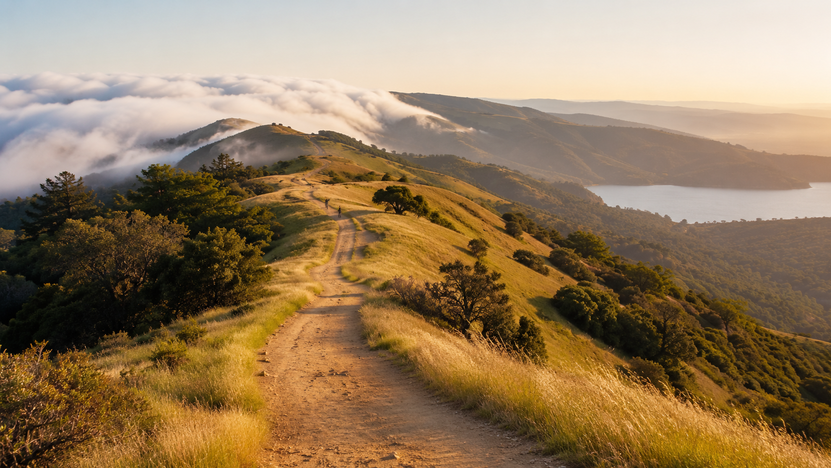
Southern Skyline Ridge Trail Opens 5.4 Miles on the Peninsula
After a wait that stretched more than twenty years, 5.4 miles of brand-new Southern Skyline Ridge Trail are scheduled to open on the San Francisco Peninsula in 2026, running parallel to Skyline Boulevard just south of Highway 92.
For homebuyers comparing Peninsula neighborhoods, this is more than a new trail. It is a meaningful upgrade to the open-space pitch for the Mid-Peninsula, on a ridgeline that has been mostly closed to the public for generations of water-quality protection.
What the Southern Skyline Ridge Trail Extension Actually Adds
The Southern Skyline Boulevard Ridge Trail Extension is led by the San Francisco Public Utilities Commission, with planning support from the Bay Area Ridge Trail Council. According to SFPUC, the project adds a multi-use trail through the Peninsula Watershed in central San Mateo County, open to hikers, cyclists, and equestrians.
The Bay Area Ridge Trail Council confirms 5.4 miles of new trail running parallel to Skyline Boulevard just south of Highway 92, complete with parking, interpretive signage, and restrooms.
Access works differently than the existing watershed trail to the north. Instead of docent-led tours, the new segment uses a permit-based system. As SFPUC describes it, users can hike, ride, or run independently after obtaining an annual permit, which includes an educational tutorial on protecting watershed habitat and drinking water quality.
The project also upgrades the existing Fifield-Cahill Ridge Trail just north of Highway 92 with a new 50-car parking lot, a new restroom, and a half-mile ADA-accessible loop trail designed to support school programs and visitors with mobility limitations.
The existing 10-mile Fifield-Cahill Ridge Trail continues to operate through docent-led tours three days a week, according to the Bay Area Ridge Trail Council.
Which Mid-Peninsula Neighborhoods Sit Closest to the New Trailheads
The new Southern Skyline trailhead sits near the Highway 92 and Skyline Boulevard junction, on the spine of the Peninsula ridge that separates the Bay from the coast. A handful of Mid-Peninsula neighborhoods are within a short drive of the new access point.
Hillsborough sits just east of Interstate 280 and is one of the closest established neighborhoods to the Highway 92 trailhead. Drivers can be at the new parking area in roughly ten to fifteen minutes from most of town.
Half Moon Bay and El Granada sit on the coastside, with Highway 92 the direct route up and over the ridge. For coastside buyers who already prioritize outdoor access, the new trail puts a major Peninsula ridgeline hike within a short drive of the coast.
Woodside and Portola Valley sit south along Skyline Boulevard. These communities have long traded on rural feel, trail access, and proximity to open space, and the new segment adds another anchor to that pitch.
Emerald Hills, in unincorporated San Mateo County above Redwood City, sits east of Skyline and picks up a relatively close-in trail option with real restroom and parking infrastructure.
Belmont Hills and the higher elevations of San Mateo, San Carlos, and Redwood City sit a short hop up Highway 92 or via 280, depending on the route. None of these are next door to the trailhead, but all are within reasonable weekend driving distance.
Why This Matters for Homebuyers Comparing the Peninsula
Buyers comparing the Peninsula to Marin or the East Bay hills often weigh trail access and open space as much as schools or commute. The Peninsula has long had Crystal Springs Trail, Edgewood, Purisima Creek, Wunderlich, and a deep regional park network, but the ridge itself has been largely off-limits because the watershed serves as a drinking water source.
Opening a 5.4-mile, multi-use, permit-access ridge segment changes that conversation. It does not turn the Peninsula into Marin, and it does not automatically lift prices in any one neighborhood. What it does is fill a long-standing gap in the Peninsula's outdoor pitch, particularly for buyers who care about hiking, cycling, and equestrian access.
For practical decisions, the trailhead location matters more than the headline. A home in Hillsborough or El Granada is genuinely close. A home in Foster City or San Carlos flatlands is much closer to the Bay Trail than to the new ridge. The mile-radius question depends on where you are starting, not on broad city labels.
What This Could Mean for Local Value
Trail proximity is one of those amenities that rarely shows up cleanly in a comparative market analysis but consistently shows up in how buyers describe what they want. Peninsula communities with longstanding trail identity, such as Woodside and Portola Valley, have reflected that preference in pricing for decades.
The careful read on the new trail is that it strengthens existing positioning more than it creates new winners. A Hillsborough listing that already markets quiet streets and oak-shaded lots picks up a new bullet point. A Half Moon Bay listing that already leans into coastside life picks up an inland counterweight. An Emerald Hills home picks up a credible ridge-access line that did not exist before.
This also fits into a broader pattern. The Bay Area Ridge Trail network has been steadily filling in gaps around the entire ring, and parcels within a mile of the network tend to benefit from being part of a marketable amenity story rather than from any single project.
The Houseberry Angle
Stories like this are exactly why Houseberry focuses on neighborhood-level research rather than only listing-level details. A home that looks similar on paper can have a very different daily experience depending on what is within a fifteen-minute drive.
The new Southern Skyline segment does not change schools, safety data, or affordability. It does change the outdoor access score for a meaningful slice of the Mid-Peninsula. For buyers comparing two finalists in different cities, that kind of amenity shift is worth checking on the map before committing.
What to Watch Next
Construction has been running through 2025 with completion expected in early 2026, according to the San Mateo Daily Journal. A few things worth tracking once the trail opens.
How the permit system rolls out. Annual capacity, cost, and waiting-list behavior will shape how usable the trail actually feels on busy weekends.
Parking. The Fifield-Cahill upgrade includes a 50-car lot. If southern trailhead capacity proves tight, expect overflow into nearby Skyline pullouts and pressure on local agencies to expand access.
Connectivity. The longer-term vision contemplates eventually linking the southern segment with the Fifield-Cahill network through Skylawn Memorial Park. A safe Highway 92 crossing would be a separate, much larger project.
Final Thoughts
A 5.4-mile public-access trail is not going to single-handedly change the Peninsula housing market. What it does is fill in a long-quiet piece of the Mid-Peninsula amenity map and give buyers comparing neighborhoods one more concrete data point to weigh.
If you are comparing neighborhoods on the Peninsula, Houseberry can help you look beyond listing photos and compare schools, safety, amenities, value, and outdoor access before you focus your search.
Southern Skyline Ridge Trail FAQs
When does the Southern Skyline Ridge Trail open?
According to the Bay Area Ridge Trail Council, 5.4 miles of new trail parallel to Skyline Boulevard south of Highway 92 are scheduled to open in 2026, with construction wrapping through late 2025.
Where is the new trailhead?
The new trail runs parallel to Skyline Boulevard just south of Highway 92 in central San Mateo County. The project also adds a new 50-car parking lot at the existing Fifield-Cahill access near Skylawn Memorial Park, per SFPUC.
Do you need a permit to hike the new trail?
Yes. Unlike the docent-led Fifield-Cahill Ridge Trail, the new Southern Skyline segment uses an annual permit-based access system that includes an educational tutorial on watershed protection, per SFPUC.
Which neighborhoods sit closest to the new trailheads?
The closest Mid-Peninsula neighborhoods include Hillsborough, Half Moon Bay, El Granada, Woodside, Portola Valley, Emerald Hills, and the upper reaches of Belmont, San Carlos, San Mateo, and Redwood City, all within a reasonable drive of the Highway 92 and Skyline Boulevard area.
Does trail access affect Peninsula home values?
Trail and open space proximity is widely cited as an amenity buyers care about, especially on the Peninsula, where communities like Woodside and Portola Valley have leaned into trail identity for decades. New regional access points generally strengthen the appeal of nearby neighborhoods rather than create sudden price swings.
Sources
• SFPUC – Southern Skyline Boulevard Ridge Trail Extension Project
• SFPUC – Approves New Six-Mile Trail Plus Other Education and Public Access Improvements
• Bay Area Ridge Trail – Dedication: Southern Skyline Ridge Trail
• Bay Area Ridge Trail – SFPUC Approves 6 New Miles of Ridge Trail
• San Mateo Daily Journal – Skyline ridge trail extension nearly done