SB 79 Takes Effect July 1: What It Means Near Bay Area Transit
SB 79 takes effect July 1, 2026, legalizing taller housing near BART, Caltrain, and VTA stations. Here is what the transit-density law means for Bay Area buyers comparing neighborhoods.
SB 79 Takes Effect July 1: What It Means Near Bay Area Transit
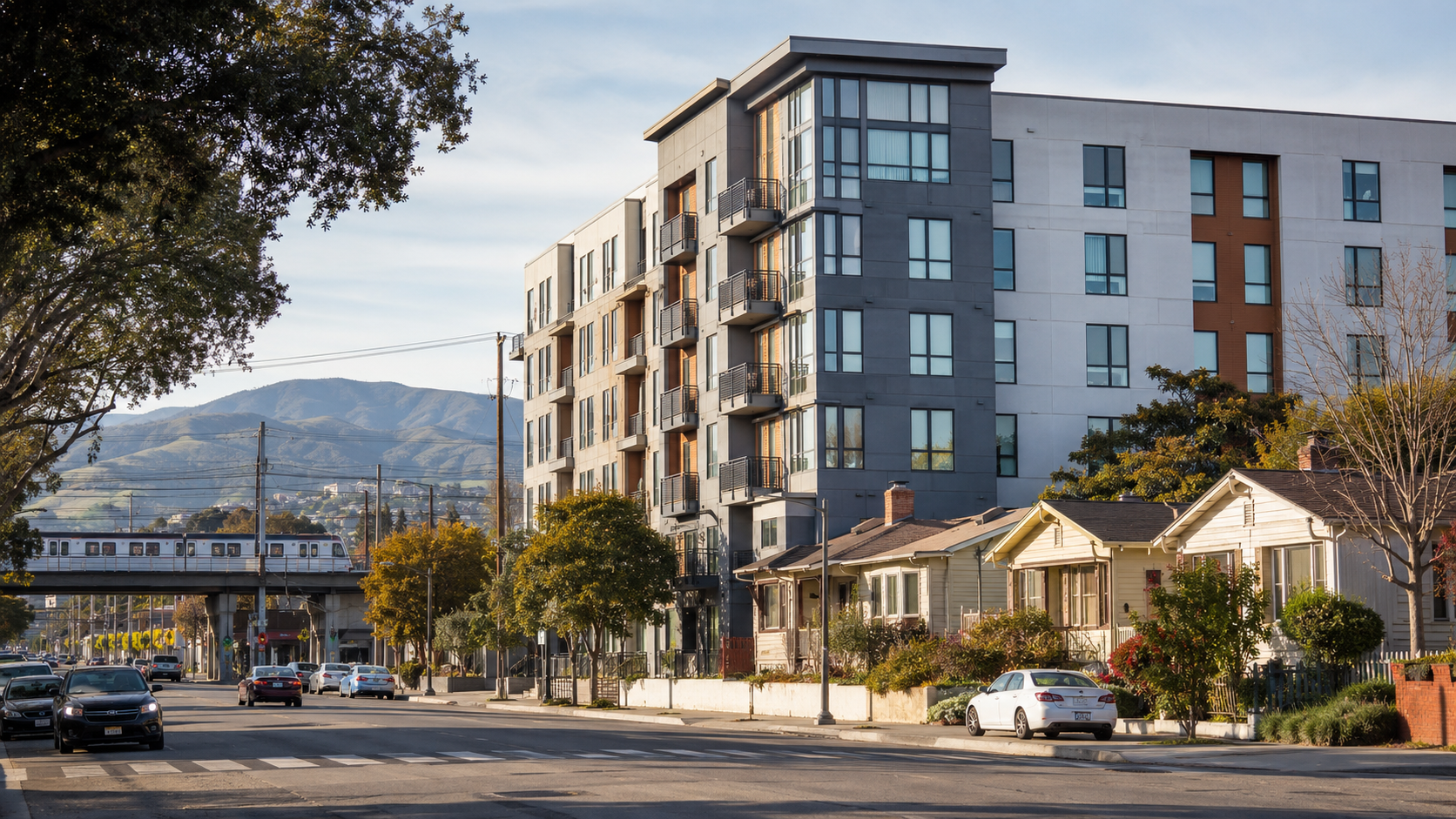
Starting July 1, 2026, the rules for what can get built near a train station in the Bay Area change in a real way. SB 79, the state's new transit-density law, makes taller apartment and condo buildings an allowed use on most residential and commercial parcels within a half mile of major rail and bus stops.
If you are watching SB 79 Bay Area transit corridors near BART, Caltrain, or VTA, this is the kind of policy shift that quietly reshapes the exact blocks you might be shopping right now. And it is not theoretical anymore. Governor Newsom signed it on October 10, 2025, and the California Department of Housing and Community Development confirms the law takes effect July 1, 2026. A parcel that could only hold one house last year may legally hold something a lot bigger this year.
Here is the practical version, with the local detail that actually matters for buyers.
What SB 79 Does Near Bay Area Transit Stations
SB 79 sorts qualifying transit stops into two tiers. Tier 1 covers heavy rail and high-frequency commuter rail, which in the Bay Area means BART and Caltrain. Tier 2 covers light rail and rapid bus, which here mostly means VTA light rail in the South Bay and Muni Metro in San Francisco. The tier of the nearest stop, not the headline, is what tells you how much a block can change.
Near a Tier 1 stop, the law allows residential buildings in the range of 65 to 75 feet, depending on how close the parcel sits to the platform. Near a Tier 2 stop, the ceiling lands closer to 55 to 65 feet. Parcels right next to a stop get an extra bump, roughly 20 more feet plus higher density, which pushes the tallest qualifying sites toward 95 feet and up to about 160 homes per acre. For reference, 75 feet is about seven stories. On a street of 1950s ranch houses, that is a noticeable change.
Two things keep this from being a free-for-all. First, cities are not forced to rewrite their zoning maps. They have to process qualifying projects starting July 1, but they can also adopt an SB 79 ordinance or a transit-oriented development alternative plan that adjusts which sites and standards apply, as long as it preserves about the same overall capacity and clears HCD review. Second, the Bay Area got a longer runway than the rest of the state. Bay Area counties can use those local exemptions and alternative plans until 2032, while most other regions have only until January 1, 2027. The full standards live in the bill text itself.
Which Bay Area Transit Stations Are Most Exposed
This is where it gets concrete. Not every station carries the same upzoning, and the tier matters more than any single number. Here is a rough read on a handful of stops, based on the line that serves them. Treat the height column as a ceiling, not a promise. The final tier map comes from the regional planning agency, and individual cities can still tune the standards.
| Station (line) | SB 79 tier | Rough height ceiling within 1/2 mile |
| Downtown Berkeley (BART) | Tier 1 | About 65 to 75 ft, up to ~95 ft on adjacent parcels |
| 19th St / Lake Merritt, Oakland (BART) | Tier 1 | About 65 to 75 ft |
| Millbrae (BART + Caltrain) | Tier 1 | About 65 to 75 ft |
| Mountain View (Caltrain + VTA) | Tier 1 / Tier 2 | About 65 to 75 ft near Caltrain |
| San Jose Diridon (Caltrain + VTA) | Tier 1 / Tier 2 | About 65 to 75 ft |
| North San Jose light rail stop (VTA) | Tier 2 | About 55 to 65 ft |
Table: example Bay Area stops by SB 79 tier and approximate height ceiling within a half mile. Heights are rough and subject to the regional tier map and local ordinances.
A few of these are neighborhoods Houseberry already covers block by block. Central Berkeleywraps the Downtown Berkeley BART station, which is about as Tier 1 as it gets. Adams Point in Oakland sits between the 19th Street BART stop and Lake Merritt, a dense, walkable pocket that already looks more like SB 79's vision than most of the region. And Central Mountain Viewsurrounds a transit center where Caltrain and VTA light rail meet, so parts of it could see both tiers in play.
Why This Matters for Homebuyers
If you are comparing neighborhoods near transit, SB 79 quietly adds a new variable. A quiet block today might get a mid-rise neighbor in a few years. That is not automatically good or bad. On the housing-shortage math, more homes near transit is exactly what the region needs, and if the Bay Area wants to stop exporting its workforce to Texas, this is roughly what the fix looks like.
But it does change what you should research. For some buyers, a livelier, denser corner with more shops in walking distance is the upside. For others, the construction years and the parking squeeze are the cost. The practical move is simple. Check the tier of the nearest stop before you fall for a listing. A house a quarter mile from a BART platform sits in a different future than one two miles away, even if they look identical in the photos.
What This Could Mean for Bay Area Neighborhoods
Expect the change to show up unevenly. Cities that already want growth near transit will lean in. Cities that have fought density for years will reach for the ordinance and alternative-plan tools, and the Bay Area's 2032 window gives them room to move slowly. So the map will not light up all at once.
And realistically, you will not wake up on July 2 to a skyline of towers. The density can phase in over the next two to three years, and large projects take longer than that to finance and build. What changes immediately is the legal baseline. That changes what is possible, which over time changes land values near the best-served stops. The corners to watch are the ones with a Tier 1 station and a lot of older, low-slung buildings sitting on land that is suddenly worth more as housing.
The Houseberry Angle
Stories like this are exactly why neighborhood-level research beats listing-level research. A home can look perfect in photos and still sit on a block whose character is about to shift, for better or worse, because of a transit stop three minutes away. SB 79 just made the station map part of the neighborhood map.
When you are weighing areas near transit, it helps to compare the things a listing never shows you. Houseberry's San Jose neighborhood rankings score blocks on value, schools, and safety, which is genuinely useful when a place like Diridon is about to absorb Caltrain, VTA, and a future BART extension all at once. Our data-backed Bay Area neighborhood guide is a good starting point if you are mapping where to focus. If you are comparing corridors, Houseberry can help you look past the photos and weigh schools, safety, amenities, and value before you commit to a block.
What to Watch Next
A few markers worth tracking. The regional planning agency, MTC and ABAG, has to publish a tiered map of qualifying stops and zones, which will turn the rough tiers above into parcel-level lines. Watch your city's council agenda for an SB 79 ordinance or alternative plan, since that is where local standards actually get set. And mark January 1, 2027, when denying a qualifying project in a high-resource area becomes a presumed violation of the state Housing Accountability Act. That is the date the law grows teeth.
Final Thoughts
SB 79 is one of the bigger zoning changes the Bay Area has seen in a generation, and it lands on July 1. It will not transform the region overnight. But if you are buying near a BART, Caltrain, or VTA stop, the tier of that stop is now part of the story of the block. Worth knowing before you sign.
SB 79 Bay Area FAQs
What does SB 79 do in the Bay Area?
It legalizes taller multifamily housing near major transit. Within a half mile of qualifying BART, Caltrain, and VTA stops, SB 79 allows buildings well above what most local zoning permitted, with the most aggressive standards near Tier 1 heavy-rail and commuter-rail stations. It takes effect July 1, 2026.
When does SB 79 take effect?
July 1, 2026, in incorporated cities, per the California Department of Housing and Community Development. Some density can phase in over the next two to three years, and Bay Area cities can use local alternative plans through 2032.
Which Bay Area transit stations get the most density under SB 79?
Tier 1 stops, served by BART and Caltrain, get the most height and density. Tier 2 stops, mostly VTA light rail and Muni Metro, get somewhat lower limits. The nearest stop's tier is the quickest signal of how much a block could change.
Will SB 79 lower home prices near transit?
Not quickly. More supply near transit tends to ease price pressure over time, but financing and building take years, and cities can shape the rollout. The clearer near-term effect is on land value and on what kind of buildings can go up near the best-served stations.
How can I compare neighborhoods near transit before buying?
Look past the listing. Check the tier of the nearest stop, then compare schools, safety, amenities, and value at the block level. Houseberry's neighborhood pages and city rankings are built for exactly that kind of side-by-side.
Sources
• California HCD: SB 79 Transit-Oriented Development
• California Legislature: SB 79 bill text
• Holland & Knight: Newsom Signs SB 79 (tiers and height standards)
• Manatt: SB 79 Transformative Upzoning Near Transit (Bay Area timeline, phasing)