

Canyon Country (unincorporated), Canyon Country (unincorporated), CA





Canyon Country (unincorporated) at a Glance
Canyon Country (unincorporated) holds an overall Houseberry score of 3.6/5. Its standout factors are safety (4.2/5) and schools (4.0/5). The trade-offs are nearby merchants (1.2/5) and public spaces (2.3/5).
Canyon Country (unincorporated) Reviews & Questions

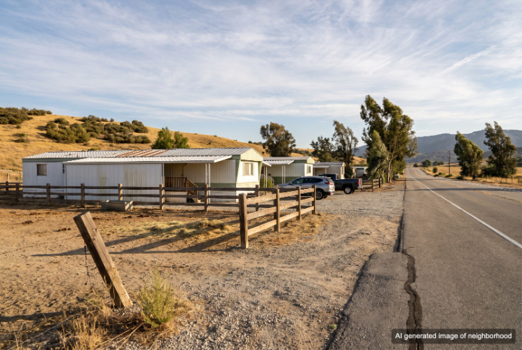
Unincorporated Canyon Country is the rural edge beyond Santa Clarita's eastern subdivisions, where Sierra Highway continues into Mint Canyon and rooftops give way to open slopes. Manufactured-home communities, scattered ranch houses and horse properties occupy canyon floors and side roads governed by Los Angeles County rather than the city. Housing is less uniform than in suburban Santa Clarita. Mobile-home communities sit along Sierra Highway, Sand Canyon Road and Vasquez Canyon Road, while older homes on larger parcels fill the spaces between them. Roads follow the terrain instead of a planned grid, and many properties look toward undeveloped ridgelines rather than neighboring backyards. Businesses along Sierra Highway serve practical rural needs. Feed, fencing and property supplies are available locally, while a small market, VFW post and a few roadside restaurants provide gathering places. The historic Halfway House Cafe lies farther north toward Agua Dulce and remains a familiar breakfast stop. Full grocery runs, parks, schools and most services are down the highway in the city of Santa Clarita. The developed side of Canyon Country offers recreation facilities, bus connections and the Via Princessa Metrolink station within a manageable drive, but residents outside the city depend on cars for nearly everything. Wildfire is the clearest tradeoff. Mint and Sand canyons border Angeles National Forest and have experienced major burns, while limited canyon routes can complicate evacuation. Heat, dust and longer emergency response logistics also come with the open setting. Unincorporated Canyon Country fits residents who want more space and a rural view without moving far from Santa Clarita services. Its ethos is practical and independent, trading suburban convenience for open land, horse setups and a stronger sense of the surrounding canyons.
Top Neighborhoods in Canyon Country (unincorporated), CA


Canyon Country (unincorporated) Amenities
 Near good merchants
1.2
 Public Spaces
2.3
 Curb Appeal
2.4
Overall Amenities score: 2.1
Canyon Country (unincorporated) Weather
Canyon Country (unincorporated) Photos
1 of 1
Schools Serving Canyon Country (unincorporated)
| School Name | Type | Grades | Houseberry School Score |
|---|---|---|---|
| Highlands Elementary | Primary | K-6 | |
| Mint Canyon Community Elementary | Primary | K-6 | |
| Arroyo Seco Junior High | Middle | 7-8 | |
| Sierra Vista Junior High | Middle | 7-8 | |
| Canyon High | High | 9-12 | |
| Saugus High | High | 9-12 | |
| Academy of the Canyons | High | 9-12 |
Click links for school listing
info at GreatSchools.org
Houseberry School Score Data
from CA Dept. of Education
Houseberry recommends using these scores as only a starting point, and conducting your own investigation into what schools fit best for your preferences. School boundaries are not guaranteed and may change. It is important to contact the appropriate school district to confirm enrollment eligibility before making any decision to move to a neighborhood.
Canyon Country (unincorporated) FAQs
7 answers
Is Canyon Country (unincorporated) a good place to live?
Canyon Country (unincorporated) holds an overall Houseberry score of 3.6 out of 5. Its strongest factors are safety (4.2/5) and schools (4.0/5). The trade-offs are nearby merchants (1.2/5) and public spaces (2.3/5).
Is Canyon Country (unincorporated) safe?
Canyon Country (unincorporated) scores 4.2 out of 5 on Houseberry's Safety Score.
Which schools serve Canyon Country (unincorporated)?
Schools serving Canyon Country (unincorporated) include Highlands Elementary (3.6/5), Mint Canyon Community Elementary (2.7/5), Arroyo Seco Junior High (4.2/5), Sierra Vista Junior High (3.5/5) and Canyon High (4.5/5). 2 more schools are listed in the Schools section on this page.
What is the weather like in Canyon Country (unincorporated)?
Canyon Country (unincorporated) receives 83% of its possible sunshine. Summer days run 59° to 90°F and winter days 42° to 63°F, August is the warmest month and rainfall averages about 16 inches a year.
Is Canyon Country (unincorporated) walkable to shops and restaurants?
Canyon Country (unincorporated) scores 1.2 out of 5 for nearby merchants and 2.3 out of 5 for public spaces. Its overall amenities score is 2.1 out of 5.
What is Canyon Country (unincorporated) known for?
Canyon Country (unincorporated) is associated with Mint Canyon, Sand Canyon Road and Sierra Highway. Its highest-scoring factors are safety (4.2/5) and schools (4.0/5).
What are the downsides of living in Canyon Country (unincorporated)?
Canyon Country (unincorporated) scores lowest on nearby merchants (1.2/5) and public spaces (2.3/5).
1 of 1
Canyon Country (unincorporated) Map
View Full Map
All information provided on this website including but not limited to - school ratings, safety, amenities, user opinions, and property data - is for general informational purposes only. We do not guarantee its reliability, accuracy, or completeness. Users should independently verify information and consult appropriate professionals as needed. By using this website, you agree Houseberry is not responsible for actions, decisions, or consequences arising from reliance on the information provided
houseberry.com - CA DRE# 01847391
 Bay East ©2025. CCAR ©2025. bridgeMLS ©2025. Information Deemed Reliable But Not Guaranteed. This information is being provided by the Bay East MLS, or CCAR MLS, or bridgeMLS. The listings presented here may or may not be listed by the Broker/Agent operating this website. This information is intended for the personal use of consumers and may not be used for any purpose other than to identify prospective properties consumers may be interested in purchasing. Data last updated at October 27, 2026 12:00 AM