Berkeley Santa Fe Right of Way Is Finally Becoming a Park
Four fenced blocks of old railroad land in southwest Berkeley are becoming gardens, a playground and a dog park. Why it took nearly thirty years, and what it does to the neighborhoods around it.
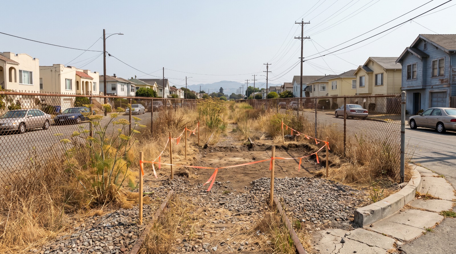
The fenced Santa Fe right of way corridor running between houses in southwest Berkeley before it becomes a park. Photo: Houseberry
If you have walked the flats west of Sacramento Street, you know the strip. Four blocks of fenced dirt and fennel running north to south between Blake and Ward, one lot wide, with houses looking at it from both sides. It has been fenced off since 1977. Berkeley has owned it since 1979.
It is finally becoming a park. About 1.3 acres across four parcels, funded by a $5 million state grant awarded in October 2021, laid out as a community farm, a garden, a playground and a dog park, one per block. Soil remediation started this June. Park construction is expected to begin this fall and the city's target for opening is summer 2027.
The reason it took nearly three decades of organizing is not permits or politics. It is arsenic and lead.
Four blocks, and each one gets a different park
The corridor runs between Acton Street and Sacramento Street, and the four blocks are Blake to Parker, Parker to Carleton, Carleton to Derby, and Derby to Ward, where it meets Sojourner Truth Court. The city calls the area South Berkeley. The public art notice calls it West Berkeley. Berkeleyside called it southwest Berkeley when it reported the news on August 4. All three are defensible, because the strip sits right on the seam, and that is worth knowing if you are searching listings by neighborhood name.
The design gives each block its own job rather than running one long greenway. Blake to Parker becomes an urban farm and education park with an outdoor classroom and an orchard. Parker to Carleton is a community garden with raised beds, benches, tool storage and compost. Carleton to Derby gets a wooden playground built for ages two to five plus a tot cycle track. Derby to Ward is the dog park, split into active and passive areas with seating and hose-off stations. Threaded through all four: pathways, lighting, bioswales, roughly twenty new trees, and $150,000 of public art designed to double as bird and insect habitat.
That is a real amenity but it is a small one. San Pablo Park, four or five blocks west, is 12.95 acres. This is 1.3. It reads as a chain of pocket parks stitched along a line, not a destination, and the plan seems clear-eyed about that.
The dirt is why it took this long
Railroad land is contaminated land. Soil testing on the trackbed turned up elevated arsenic and lead, and California's Department of Toxic Substances Control did not approve the final removal action workplan until November 2025. Everything downstream waited on that.
Then the bids came in. Berkeley opened eleven of them on December 18, 2025, ranging from $2,953,886 to $4,699,667, against an engineer's estimate of $1,560,000. Only the low bid fit the budget. On January 27, 2026 the City Council adopted Resolution 72,098 and awarded Carone and Company a contract of up to $3,396,969 to haul out the contaminated soil and replace it with clean fill. The vote was all ayes.
Sit with that for a second. The cleanup contract alone came in at more than double what the city's own engineers estimated, and it consumes about two thirds of the $5 million grant before a single raised bed gets built. Berkeley expects to spend $19,606 a year maintaining the finished park, which is the cheap part. Getting to the starting line is what cost.
It is also the most transferable lesson in this story. Every old industrial strip and rail spur in the East Bay that people look at and think "why is nothing there" has some version of this file behind it. Berkeley is currently dealing with a different flavor of the same problem at its stalled construction sites. Land sitting empty in an expensive city almost always has a reason, and the reason is usually expensive.
West Berkeley ranks 16th of 18 on the score a park actually moves
A park does not move a school score or a crime score. It moves amenities, which is the score that tracks what is within reach on foot. And the two neighborhoods this corridor runs through are exactly the ones that need the help.
| Place | Median sale price | Amenities | Amenities rank of 18 | Safety |
|---|---|---|---|---|
| West Berkeley | $1.01M (July 2026) | 3.8 / 5 | 16th | 2.1 / 5 |
| South Berkeley | $1.19M (June 2026) | 4.0 / 5 | 11th | 2.1 / 5 |
| Berkeley citywide | $1.77M (July 2026) | 4.0 / 5 | n/a | 3.4 / 5 |
West Berkeley sits 17th of 18 Berkeley neighborhoods on our overall score and 16th of 18 on amenities. Its median sale price of about $1.01 million in July 2026 is roughly 57 percent of the $1.77 million citywide median, a gap near $760,000. These are small-sample monthly medians and they swing hard, so read the level rather than the month-to-month move.
The city's own grant application put a harder number on the gap than any score can. The service area around the corridor, 11,285 residents, has 1.03 acres of park per 1,000 people against a Berkeley average of 2.28. Less than half the city allotment, in a stretch where 695 households have no car and cannot simply drive to Tilden. That is not a vibe. That is a measurable deficit, and it is the one this project actually closes.
The part nobody wants to say out loud
Southwest Berkeley is historically Black and historically industrial. Berkeley's Black population peaked above 27,000 in 1970 and by the 2020 Census fewer than half remained. The grant service area was 38 percent African American and 62 percent non-white in 2021, with a median household income of $86,484. Putting a park into a neighborhood with that history invites an obvious question, and the honest answer is uncomfortable.
The comforting version goes: it is only 1.3 acres, so it cannot possibly move housing costs. The research does not support that. A 2020 study in Urban Studies looking at new parks across ten U.S. cities found that a park's function and its location predicted whether the area gentrified, and that park size did not. Small is not the same as harmless. What the same research does suggest is that the highest-risk configuration is a new greenway with an active transportation component near downtown, and this is neither. Two of the four blocks are community gardens and an orchard, which serve people who already live there rather than drawing crowds from across the city.
Berkeley also has rent stabilization, which changes the math relative to most of the cities in that literature. So the fair statement is that the displacement risk here is real, is smaller than the High Line, and is not zero because the park is little. Anyone telling you otherwise in either direction is arguing rather than reading.
None of that is a reason to not build it. A neighborhood with half the city's park acreage per person, elevated rates of hypertension and heart disease, and residents who have organized for this since the 1990s should get the park. The trade-off deserves to be named out loud instead of discovered later.
How to read these blocks if you are shopping here
A few practical notes, because this is the stretch where listings will start mentioning the park long before the park exists.
Distance matters more than people think. The research on parks and home values is strongest for homes within a couple of blocks and fades fast after that, and for small active parks the picture for the houses directly facing them is genuinely mixed, because a dog run and a tot track come with noise and traffic. Fronting the Derby-to-Ward block is a different proposition from being two streets over. Go stand there.
On schools, the nearest elementaries are Malcolm X on Prince Street and Rosa Parks on Allston Way, but Berkeley Unified assigns elementary students by zone through a controlled-choice process rather than by a street-level attendance boundary. Do not let a listing imply otherwise.
And on timing, summer 2027 is a target, not a delivery date, on a project whose remediation bid came in at more than double the estimate. If you are pricing in the finished park today, you are paying 2027 money in 2026. The way we look at it when we compare neighborhoods at Houseberry, the useful move is to buy the block you would want if the park slipped two years, and treat the opening as the upside rather than the thesis. How West Berkeley scores today and how South Berkeley scores today are the numbers you are actually buying.
Forty-seven years after the last Santa Fe train ran the East Bay line, four blocks of it stop being a fence. That is worth something either way.
Sources
City of Berkeley, Santa Fe Trackbed to Park Conversion project page
City of Berkeley, January 27, 2026 council item and contract staff report
City of Berkeley, January 27, 2026 annotated council agenda
California State Parks, Proposition 68 Statewide Parks Program Round Four grant list (Oct 2021)
City of Berkeley, Proposition 68 Santa Fe right of way grant application (Mar 2021)
Rigolon and Nemeth, Green gentrification or just green enough, Urban Studies (2020)
Crompton, The impact of parks on property values, Journal of Leisure Research (2001)
Daily Californian data project, Berkeley's Black population decline
All information provided on this website including but not limited to - school ratings, safety, amenities, user opinions, and property data - is for general informational purposes only. We do not guarantee its reliability, accuracy, or completeness. Users should independently verify information and consult appropriate professionals as needed. By using this website, you agree Houseberry is not responsible for actions, decisions, or consequences arising from reliance on the information provided
houseberry.com - CA DRE# 01847391
 Bay East ©2025. CCAR ©2025. bridgeMLS ©2025. Information Deemed Reliable But Not Guaranteed. This information is being provided by the Bay East MLS, or CCAR MLS, or bridgeMLS. The listings presented here may or may not be listed by the Broker/Agent operating this website. This information is intended for the personal use of consumers and may not be used for any purpose other than to identify prospective properties consumers may be interested in purchasing. Data last updated at September 18, 2026 12:00 AM