San Pablo Avenue Specific Plan: What Could Rise on Your Block
Berkeley City Council votes Tuesday on the San Pablo Avenue Specific Plan, built for up to 6,750 new homes and a proposed 145-homes-per-acre minimum. Here is the lot-by-lot math for West Berkeley, Oceanview and Westbrae buyers.
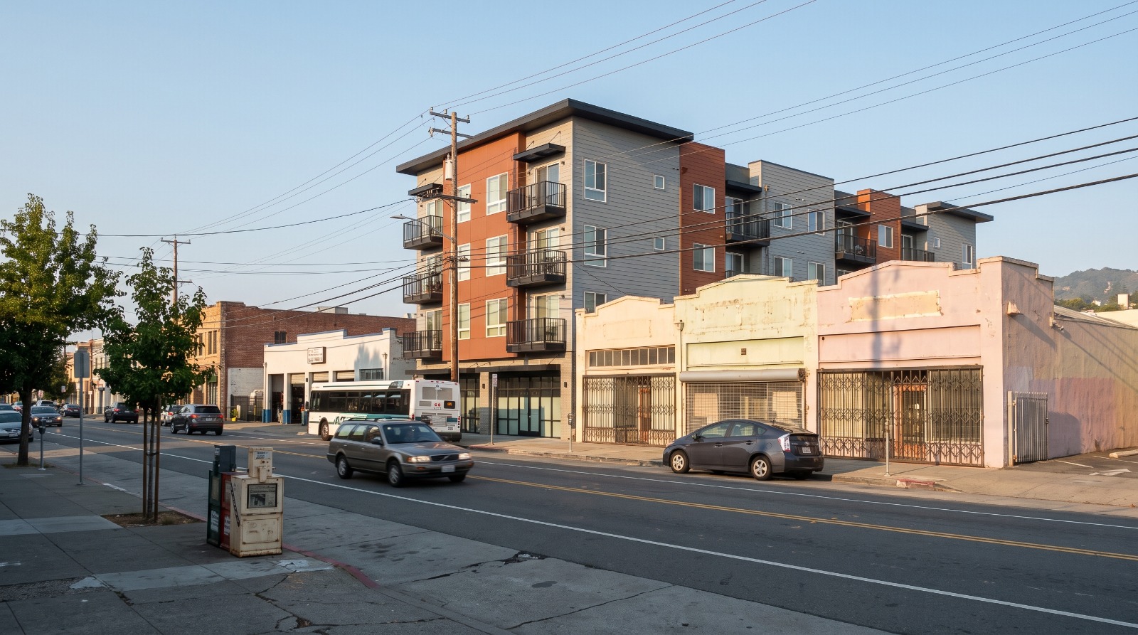
San Pablo Avenue in West Berkeley, where one-story storefronts sit beside a newer five-story apartment building covered by the specific plan. Photo: Houseberry
Item 34 on Tuesday's Berkeley City Council agenda will decide what gets built along 2.35 miles of San Pablo Avenue for years, and the most important page in the packet is a supplemental added after the main report. It asks the council to require at least 145 homes per acre on any residential or mixed-use project along San Pablo Avenue. On a standard 5,000-square-foot lot, that works out to about 17 homes.
The San Pablo Avenue Specific Plan itself is built for 6,500 to 6,750 net new homes over the life of the plan, compared with about 3,500 if the city left today's zoning alone. The council meets at 6 p.m. on Sept. 29 and could adopt the whole package in one night. We will have the outcome Wednesday. Until then, here is what the math means block by block.
What the council is actually voting on Tuesday
Council is being asked to take five actions under one agenda item, according to the Sept. 29 agenda. It is a public hearing on the Action Calendar, at the School District Board Room at 1231 Addison St.
- CEQA. Adopt an addendum to the Housing Element environmental impact report instead of a new EIR.
- The plan. Adopt the San Pablo Avenue Specific Plan and its design standards.
- General Plan. Approve the land use redesignations that line the General Plan up with the new plan.
- Two old plans retired. Rescind the West Berkeley Plan and the San Pablo Avenue Public Improvements Plan.
- Zoning. First reading of the ordinance creating the C-SP district, Chapter 23.202.160, plus conforming code changes.
That last one matters for timing. An ordinance in Berkeley needs a second reading at a later meeting before it takes effect, so a yes vote Tuesday starts the clock rather than finishing it. The plan has been in the works since June 2023, with a public review draft in October 2025 and three Planning Commission sessions before the commission's final recommendation in June.
Where the new homes are supposed to go
The short answer is three intersections. The consultants' buildout memo (Appendix C, revised August 2025) assumes projects in the Tier 1 nodes reach about 250 homes per acre, far above anything else on the corridor.
The October 2025 public review draft put those Tier 1 nodes at University Avenue, Ashby Avenue and Gilman Street, with Tier 2 nodes at Cedar Street and Dwight Way. In that draft, Tier 1 sites could go to 85 feet and eight stories. Everywhere else on the avenue, the model assumes about 140 homes per acre.
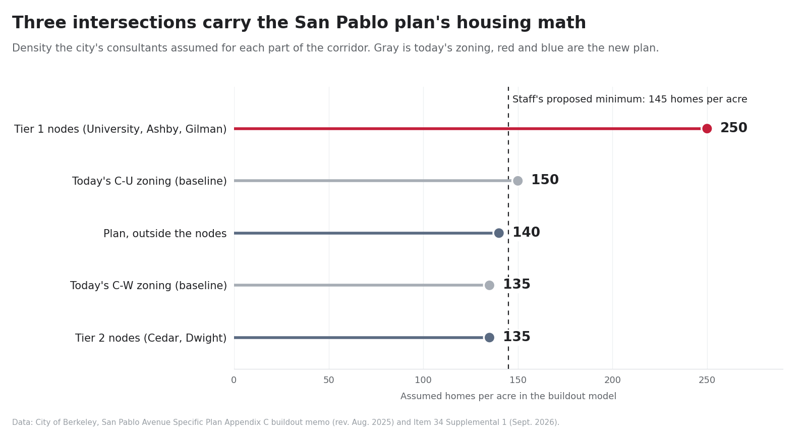
Look at the chart and one thing jumps out. Outside the nodes, the plan's assumed density (140) is barely different from today's C-W baseline (135). The big gain comes from the height and density allowed at the intersections, plus more sites becoming feasible at all. That is why the node locations, not the corridor as a whole, are where buyers should pay attention.
The site inventory behind the numbers is modest. The memo counts 51 housing opportunity sites, including 12 already in the pipeline and 6 more flagged as likely to develop. That is not a lot of dirt for 6,500 homes, which is exactly why staff wants a floor on density.
The 145-homes-per-acre minimum, lot by lot
The minimum density is the one real disagreement between staff and the Planning Commission. Supplemental 1, submitted by Jordan Klein of the Planning and Development Department, adds a 145 dwelling-units-per-acre minimum for residential and mixed-use projects in C-SP. The commission's June 3 version had "no minimum." Neither version sets a maximum density.
The supplemental's C-SP table also sets a 4.25 floor-area ratio and 75 feet and seven stories for residential and mixed-use buildings, and 40 feet and three stories for non-residential ones. Here is what a 145 floor means on real San Pablo lot sizes, next to what the Tier 1 assumption would imply.
| Lot size | Minimum homes at 145 per acre | Homes at the Tier 1 assumption (250 per acre) |
|---|---|---|
| 5,000 sq ft (a typical 50-by-100 lot) | About 17 | About 29 |
| 7,500 sq ft | About 25 | About 43 |
| 10,000 sq ft | About 33 | About 57 |
| Half an acre (21,780 sq ft) | About 73 | About 125 |
| One acre | 145 | 250 |
These are Houseberry's own calculations from the city's density figures, rounded, not project approvals. But they show what the rule does. A 10,000-square-foot corner that might otherwise get 12 townhomes would need about 33 homes. With a 4.25 floor-area ratio, that lot allows roughly 42,500 square feet of building, so 33 homes averages under 1,300 gross square feet each. The minimum fits comfortably inside the envelope. It just stops someone from building well below it.
I think staff has this right. San Pablo is a trunk transit line with a 2.35-mile supply of commercial lots, and every one that gets a low-density project is gone for 50 years. If you believe the corridor should carry a real share of Berkeley's housing, a floor is how you protect the sites. The draft plan itself notes that about 31 percent of the city's regional housing target, 2,023 units, falls in the plan area.
The honest counterargument is feasibility. Construction costs are high, and a small-lot owner who can pencil 10 units but not 17 may simply build nothing. The supplemental lists no carve-out for small lots or existing buildings, so watch whether council adds one Tuesday.
The commercial space trade-off
San Pablo will get more homes and less shop space. The buildout memo projects a net loss of 225,000 to 320,000 square feet of commercial space under the plan, a 15 to 21 percent drop, versus a smaller 150,000 to 215,000 square-foot loss under current zoning. The draft counts about 1.49 million square feet of commercial space on the corridor today.
That sounds worse than it is. Much of what disappears is one-story auto repair, storage and single-tenant buildings (anyone who has driven past Dwight on a Saturday knows the look). The draft requires ground-floor commercial at the nodes, so the shopping should concentrate where the foot traffic will be. Ground-floor vacancy on the corridor peaked at 15.5 percent in 2023 before falling to 7.1 percent in 2024, per the draft. Fewer, better storefronts is a reasonable bet.
Still, if a specific shop or service is why you like your block, it is worth knowing whether its building sits on an opportunity site.
What this means if you are buying near San Pablo
Buyers in the flats west of Sacramento Street get the most direct effect, good and bad. The plan is aimed at parcels fronting the avenue, with some changes reaching about two blocks off it, mostly around University, according to SF YIMBY's preview of the June hearing. Side streets of single-family homes are not being turned into seven-story zones.
Here is how the neighborhoods along the corridor look in our data right now.
- Berkeley Oceanview, the flatland neighborhood west of San Pablo toward I-80 where Berkeley was first settled, had a median of about $1.15 million in August 2026. That is roughly a third below the $1.73 million Berkeley citywide median the same month. Its 4.6 amenities score is the highest of Berkeley's 18 ranked neighborhoods, and its 2.7 safety score is below the city's middle.
- Westbrae, the northwest pocket along the Ohlone Greenway near the Gilman node, reached about $1.56 million in August 2026, up from $1.32 million in September 2025.
- West Berkeley, the mix of industrial blocks and cottages between San Pablo and Fourth Street, ran about $1.23 million in August 2026 and ranks 17th of 18 overall, with a 2.1 safety score.
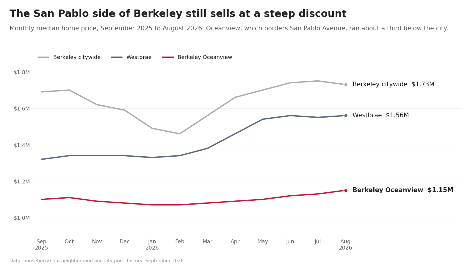
The discount on the San Pablo side is real, and it is not because the area lacks things to walk to. The trade-off is that you are buying next to a corridor designed to change. A single-family house a block off the avenue near University or Gilman could, over the next decade, look onto seven- and eight-story buildings with ground-floor shops.
For some buyers that is the pitch: more neighbors, more storefronts, more reasons for AC Transit to run often. For others it is a dealbreaker. Neither is wrong. What matters is knowing which one you are before you write the offer.
A few practical checks: look up whether the parcels facing the avenue near you are on the plan's opportunity-site map in the draft, note which node you are closest to, and read the height standards for that node. Land in West Berkeley is still cheap by Berkeley standards, as the $14.5 million sale of the University Inn near University and Eighth showed this month. Cheap land and higher zoning are exactly the conditions that get projects started.
Does the plan change what my own house can become?
Probably not directly, unless your lot fronts San Pablo. The C-SP district applies to the corridor parcels, and residential side streets keep their own zoning, including the state rules that already allow ADUs and lot splits. The indirect effect is the one to think about: what gets built across the street from you, and how that changes traffic, parking and the shops you walk to.
After Tuesday: second reading and the first projects
If council adopts the plan Tuesday, the C-SP ordinance returns for a second reading at a later meeting before the new zoning takes effect. The minimum density question is the piece most likely to be amended from the dais, so the version that passes may not match either the commission's or staff's.
We will report the outcome Wednesday and update our Berkeley neighborhood rankings coverage as projects are filed. For anyone shopping in Oceanview, Westbrae or West Berkeley this fall, the useful habit is the one we always come back to at Houseberry: learn what is planned for the neighborhood before you fall for the house.
Sources
- City of Berkeley, City Council Regular Meeting eAgenda, Sept. 29, 2026, Item 34
- City of Berkeley, Item 34 Supplemental 1, Minimum Density, Sept. 2026
- City of Berkeley, Item 34 staff report, Adoption of San Pablo Avenue Specific Plan
- City of Berkeley, San Pablo Avenue Specific Plan Appendix C, Buildout Summary Memorandum, rev. Aug. 29, 2025
- City of Berkeley, San Pablo Avenue Specific Plan Public Review Draft, Oct. 2025
- City of Berkeley, San Pablo Avenue Specific Plan project page
- SF YIMBY, preview of the June 3, 2026 Planning Commission hearing
- Houseberry Berkeley neighborhood rankings and neighborhood price pages, accessed Sept. 28, 2026
Map of Berkeley Neighborhoods
Loading map...
View Full Map
Top Neighborhoods in Berkeley, CA


All information provided on this website including but not limited to - school ratings, safety, amenities, user opinions, and property data - is for general informational purposes only. We do not guarantee its reliability, accuracy, or completeness. Users should independently verify information and consult appropriate professionals as needed. By using this website, you agree Houseberry is not responsible for actions, decisions, or consequences arising from reliance on the information provided
houseberry.com - CA DRE# 01847391
 Bay East ©2025. CCAR ©2025. bridgeMLS ©2025. Information Deemed Reliable But Not Guaranteed. This information is being provided by the Bay East MLS, or CCAR MLS, or bridgeMLS. The listings presented here may or may not be listed by the Broker/Agent operating this website. This information is intended for the personal use of consumers and may not be used for any purpose other than to identify prospective properties consumers may be interested in purchasing. Data last updated at September 28, 2026 12:00 AM