130 Downtown Hayward Parcels, Up to 210 Homes an Acre
The Hayward City Council holds a hearing on Tuesday, October 6, on remapping 130 downtown parcels and setting a range of 34.8 to 210 homes per acre near the Downtown Hayward BART station.

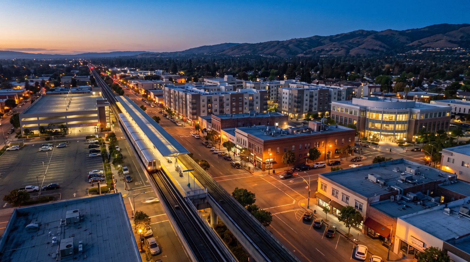
Aerial view of downtown Hayward and the BART station at blue hour, the area covered by the General Plan amendment Photo: Houseberry
The Hayward City Council holds a public hearing on Tuesday, October 6, on a Hayward General Plan amendment that would remap 130 downtown parcels and set a density range of 34.8 to 210 homes per net acre. It is agenda item 13, and the vote has not happened yet. If the council adopts it, the city’s long-range land use map for downtown would match the zoning it adopted with the Downtown Specific Plan in 2019.
The item, file PH 26-039, is the last formal step in a process that started at the Planning Commission in August. Its 210 ceiling also matches the figure BART is already showing the public for the three parcels it owns around the Downtown Hayward BART station.
Two changes to the Hayward General Plan, both on paper
The amendment does two things, according to the council agenda text for PH 26-039. It rewrites the density rule for downtown’s two City Center designations, and it redraws the land use map so 130 more parcels carry the CC-ROC label.
The density change is the bigger shift. Hayward’s General Plan mixed-use designations page says maximum densities in both City Center categories “range from 40 to 110 dwelling units per net acre” today. The proposal raises the top of that range to 210 and sets a floor of 34.8. That floor is the same number as the ceiling for Hayward’s High Density Residential and Commercial/High Density Residential designations, so downtown’s minimum would start where the rest of the city’s densest categories stop.
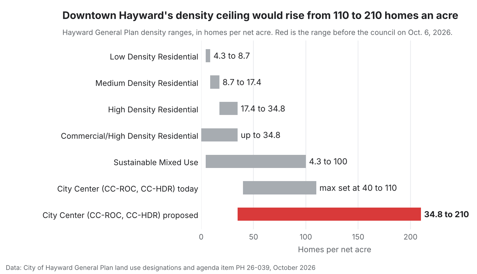
The Planning Commission’s August staff summary listed the range as 40 to 210. The commission approved its recommendation “including a modification,” and the version before the council lists 34.8 to 210. The agenda text does not spell out what the modification was.
Which 130 parcels move, and from what
The 130 parcels currently sit in four designations: Commercial/High Density Residential, Medium Density Residential, Parks and Recreation, and Sustainable Mixed Use. The agenda text locates the Parks and Recreation parcels between Mission Boulevard and A Street. All 130 would become CC-ROC “to be consistent with the existing zoning and fully implement the Specific Plan vision.”
In other words, the zoning on these lots was already updated with the Specific Plan, while the General Plan map still shows the older designations. Medium Density Residential, for comparison, tops out at 17.4 homes per acre. The parcel-by-parcel map is Attachment IV to the council item, and the agenda text itself does not list addresses.
The 2019 Downtown Specific Plan set the direction
Hayward approved the Downtown Specific Plan on April 30, 2019. Its environmental filing with the state describes a 320-acre plan area with room for up to 3,427 new homes and 1.9 million square feet of non-residential space, adding an estimated 7,539 residents and 6,333 jobs over 20 years.
That is why the council is not being asked to approve a new environmental review. The resolution finds the amendment “fully consistent” with the Specific Plan’s 2019 environmental impact report. The agenda text also ties the change to Hayward’s 2023 to 2031 Housing Element, which plans for 4,624 new homes citywide over that period, and to the Transit-Oriented Communities Policy that the Metropolitan Transportation Commission adopted on September 28, 2022. MTC’s policy sets residential density standards within a half mile of rail stations and links them to regional transportation funding.
What the 210 ceiling means for BART’s station parcels
BART owns three parcels around the Downtown Hayward station, measuring 2.5, 2.4 and 2.1 acres, 7 acres in all. They are the west side surface parking lot and garage driveway, the vacant lot between A, B and Montgomery streets, and the east side passenger and bus loading area, according to BART’s April 2026 announcement.
BART’s open house boards list a density of 40 to 210 homes per acre for those sites, with a footnote that the range applies “with the General Plan Updates (scheduled for mid-late 2026).” The same boards show building heights up to 11 stories with some setbacks, and a cap of half a parking space per home under state law. Hoodline’s April coverage reported that at least 20 percent of the homes would be affordable to low and very low income households.
As rough arithmetic, not a proposal, 7 acres at 210 homes per acre is about 1,470 homes as an outer limit, before plazas, setbacks and the bus area take their share. BART has not published a unit count. Its stated next steps are finalizing goals for the sites, then soliciting and selecting a developer, with design and permitting after that.
For a sense of what already stands downtown, Pimentel Place at 22648 2nd Street opened in December 2025 as a five story building with 57 affordable apartments, per SF YIMBY.
Downtown Hayward next to its neighbors
Downtown Hayward, the walkable core around City Hall, the BART station and the B Street restaurant blocks, scores 2.7 out of 5 overall on Houseberry and ranks 16th of 20 Hayward neighborhoods. Its amenities score of 4.0 is the highest in the city. Its safety score of 1.9 is tied for the lowest.
| Neighborhood | Overall | Safety | Amenities | Median price (month) |
|---|---|---|---|---|
| Downtown Hayward | 2.7 | 1.9 | 4.0 | $557,500 (Aug 2026) |
| Hayward North | 2.5 | 1.9 | 3.2 | $572,440 (Sep 2026) |
| Upper B Street | 2.9 | 3.0 | 3.3 | $792,590 (Sep 2026) |
| Burbank | 3.4 | 4.4 | 3.4 | $811,510 (Sep 2026) |
| Mission Foothills | 2.9 | 2.6 | 3.5 | $832,470 (Sep 2026) |
Downtown Hayward’s median was about $557,500 in August 2026, roughly 8 percent below the $605,330 it showed in September 2025, and well under Hayward’s citywide median of about $935,430 in July 2026. Next door, Upper B Street, the residential neighborhood along upper B Street that includes San Felipe Community Park, sat near $792,590 in September 2026.
In this group, Downtown Hayward has the highest amenities score and the lowest median price, and it shares the lowest safety score with Hayward North. Nothing in Tuesday’s vote changes those numbers. What it changes is how much housing the long-range rules allow on downtown’s City Center parcels.
What this vote does and does not decide
A General Plan amendment sets the long-range rules. It does not approve a single building, and the Specific Plan’s 2019 zoning already governs what gets permitted downtown. The practical effect is consistency between the map and the zoning, which the city says will make Hayward more competitive for state and regional grant funding.
For nearby owners in Upper B Street, Mission Foothills or Hayward North, the trade-off is the familiar one with station-area plans. More homes and businesses near BART can bring more foot traffic and more places to walk to, along with years of construction and taller buildings on blocks that are mostly two and three stories today. All six recorded commission votes in August were in favor, and the council hearing is the next chance for public comment.
What happens Tuesday night
The hearing is item 13 on the October 6 City Council agenda, with the meeting starting at 7:00 p.m. in the Council Chambers at 777 B Street.
If it passes, the next milestone to watch is BART’s developer selection for the station parcels, one of the first projects that could use the new 210 ceiling. For how downtown compares across the city, our guide to the best neighborhoods in Hayward and the full Hayward neighborhood rankings cover all 20 neighborhoods.
Sources
- City of Hayward, PH 26-039 agenda text, City Council meeting of October 6, 2026
- City of Hayward, City Council meeting detail, October 6, 2026
- City of Hayward, PH 26-036 Planning Commission agenda text, August 27, 2026
- City of Hayward, General Plan mixed-use land use designations
- City of Hayward, General Plan residential land use designations
- CEQAnet, Hayward Downtown Specific Plan Notice of Determination
- City of Hayward, Housing Element projected housing needs
- MTC, Transit-Oriented Communities Policy adoption, September 2022
- BART, Hayward Station TOD open houses, April 2026
- BART, Hayward Station TOD open house boards
- Hoodline, Hayward BART station housing plans, April 2026
- SF YIMBY, Pimentel Place and Mission Paradise openings, December 2025
- Neighborhood scores and median prices from houseberry.com neighborhood and city pages, October 2026
The Houseberry Research Team is Houseberry's reporting team: Bay Area real estate analysts, data specialists and longtime local market watchers. Every day we check the public record: building permits, city council and planning agendas, county recorder filings, state housing bills, police incident data and school results. Then we tie each story to what it means for specific neighborhoods, using Houseberry's own neighborhood data on prices, appreciation, safety, schools and amenities. Questions or corrections: Contact us.
Map of Hayward Neighborhoods
Loading map...
View Full Map
Top Neighborhoods in Hayward, CA



All information provided on this website including but not limited to - school ratings, safety, amenities, user opinions, and property data - is for general informational purposes only. We do not guarantee its reliability, accuracy, or completeness. Users should independently verify information and consult appropriate professionals as needed. By using this website, you agree Houseberry is not responsible for actions, decisions, or consequences arising from reliance on the information provided
houseberry.com - CA DRE# 01847391
 Bay East ©2025. CCAR ©2025. bridgeMLS ©2025. Information Deemed Reliable But Not Guaranteed. This information is being provided by the Bay East MLS, or CCAR MLS, or bridgeMLS. The listings presented here may or may not be listed by the Broker/Agent operating this website. This information is intended for the personal use of consumers and may not be used for any purpose other than to identify prospective properties consumers may be interested in purchasing. Data last updated at October 3, 2026 12:00 AM