East Bay Regional Park District Wildfire Map, Explained
The state is paying the East Bay Regional Park District to rank where brush clearing and tree thinning should happen first on all its land. Here is what that means for the hillside homes next door, in plain English.
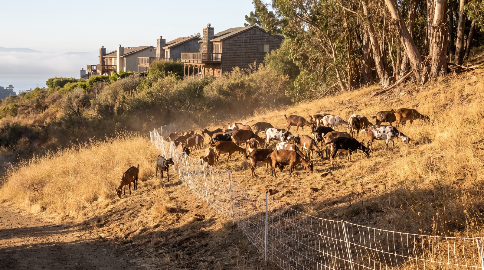
Goats grazing dry grass below hillside homes in the East Bay hills, part of East Bay Regional Park District wildfire work. Photo: Houseberry
If you walk the fire roads above Berkeley or Oakland in late summer, you have probably met the goats. A herd works its way across a dry slope behind a white mesh fence, and a week later the hillside looks like a fresh buzz cut.
Somebody decides which slope gets the goats first. Starting now, that decision gets a map. The California State Coastal Conservancy is paying the East Bay Regional Park District to build a ranked plan for where fire work should happen first across all 126,000 acres of its parkland in Alameda and Contra Costa counties. It is a plan, not a chainsaw. Nothing gets cut because of this piece of the grant alone.
What the East Bay Regional Park District wildfire map actually is
Think of it as a ranked to-do list drawn on a map. The park district has far more hillside than it has crews, so it needs a fair way to decide what comes first.
The Conservancy's September 17 staff report calls it a “vegetation management prioritization framework.” In everyday words, that means computer mapping software that layers what could burn, where the rare plants and animals are, where the trails and access roads run, and how weather moves through each canyon. The park district's request for bids says the ranking should balance wildfire risk, the health of the land and public access. Consultant bids were due March 10, 2026.
The result will be an online map and app that park staff use to plan every future fire project on their land. The report does not say whether the public will get to see it. That is worth asking about.
The grant also pays for an online workshop, so other local agencies and nonprofits can learn to build their own versions.
You may see the phrase “CEQA notice of exemption” on the state filing. CEQA is California's environmental review law. A notice of exemption is a short form saying a project is small or harmless enough to skip a full environmental study. Making a map and holding a video call does not touch a single tree, so it qualifies.
Who is paying, and how much
State money covers almost all of it, and the new piece is small. The Conservancy is a state agency, and the extra $100,000 comes from a $20 million wildfire block grant it receives from the California Department of Conservation.
| Money source | Amount | What it covers |
|---|---|---|
| Coastal Conservancy, September 2024 | $2,075,000 | About 130 acres of fuel work in three parks, a 34-acre fuel break at Lake Chabot, and equipment |
| Coastal Conservancy, September 2026 | $100,000 | The priority map, the online tools and the workshop |
| East Bay Regional Park District | $376,965 | Non-cash contributions from the district |
| Total project | $2,551,965 | Everything above |
Two notes on that table. The 2024 amount comes from the Conservancy's own announcement, which named Tilden, Anthony Chabot and Carquinez Strait. And the September 22 filing lists no dollar figure at all. The $100,000 comes from the staff report the Conservancy board took up in Fort Bragg on September 17, and the notice filed five days later says the Conservancy is approving the grant.
What fire work looks like on the ground
Most of it is surprisingly low-tech. Fire crews call anything that can burn “fuel.” That means dry grass, brush, fallen branches and the peeling bark that piles up under eucalyptus trees. “Fuel work” just means getting less of it near the places fire likes to travel.
According to the park district's fuels management page, the toolkit includes hand crews, mowing, weed-eating, chipping, thinning crowded stands of trees, removing dead trees and some prescribed burns. Cattle, sheep and goats graze about 86,800 acres of park land every year. The district says crews and machines treat more than 1,000 acres a year on top of that.
The bigger jobs look more dramatic. In September 2025 the district finished a 667-acre project at Anthony Chabot Regional Park that removed eucalyptus on a large scale and turned the debris into biochar. This year's Tilden projects run from May through December 2026 near Golf Course Drive, Shasta Road, Park Hills Road and Wildcat Canyon Road, with some trails and group camps closed while machines are working.
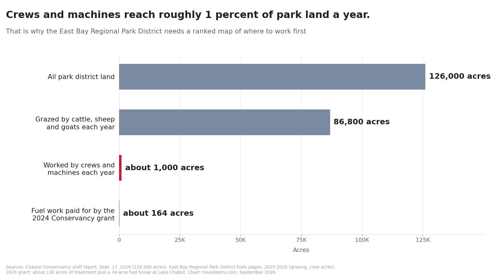
That gap is the whole reason for the map. Grazing covers a lot of grass cheaply. But the careful work, like thinning trees near a ridge of houses, happens on about 1 percent of the land each year. Picking the right 1 percent is the job.
There is history here, too. The October 1991 Oakland Hills firestorm killed 25 people and destroyed 3,469 homes and apartment units. Hillside residents who were here for it do not need a reminder. Newer neighbors can think of this map as the slow, unglamorous follow-through.
The hillside neighborhoods that share a fence line with the parks
The parks run along the back of some of the East Bay's most sought-after streets, and the prices show it. We pulled six neighborhoods on our East Bay neighborhood rankings that sit right against district land, and checked each one's last 12 months of sales.
Berkeley Hills, the upper Berkeley streets off Grizzly Peak Boulevard that back onto Tilden Regional Park, had a median sale price of about $1.80 million in August 2026. It scores 4.5 out of 5 on our Public Spaces measure. A little farther south, Claremont Hills sits below Claremont Canyon Regional Preserve at about $1.94 million, with a perfect 5.0 safety score.
In Oakland, Skyline-Hillcrest Estates, along Skyline Boulevard with Redwood Regional Park trailheads on its northern edge, was about $1.68 million in August. Leona Heights, where the Leona Canyon trail starts, was about $1.02 million in July 2026. Across the ridge in Orinda, El Toyonal has trails into Tilden and a 4.9 school score.
Castro Valley is the one to watch for this specific grant. Lake Chabot Regional Park, home of the new 34-acre fuel break, is its backyard. Its median rose from about $1.15 million in September 2025 to about $1.22 million in August 2026, roughly 6 percent in a year.
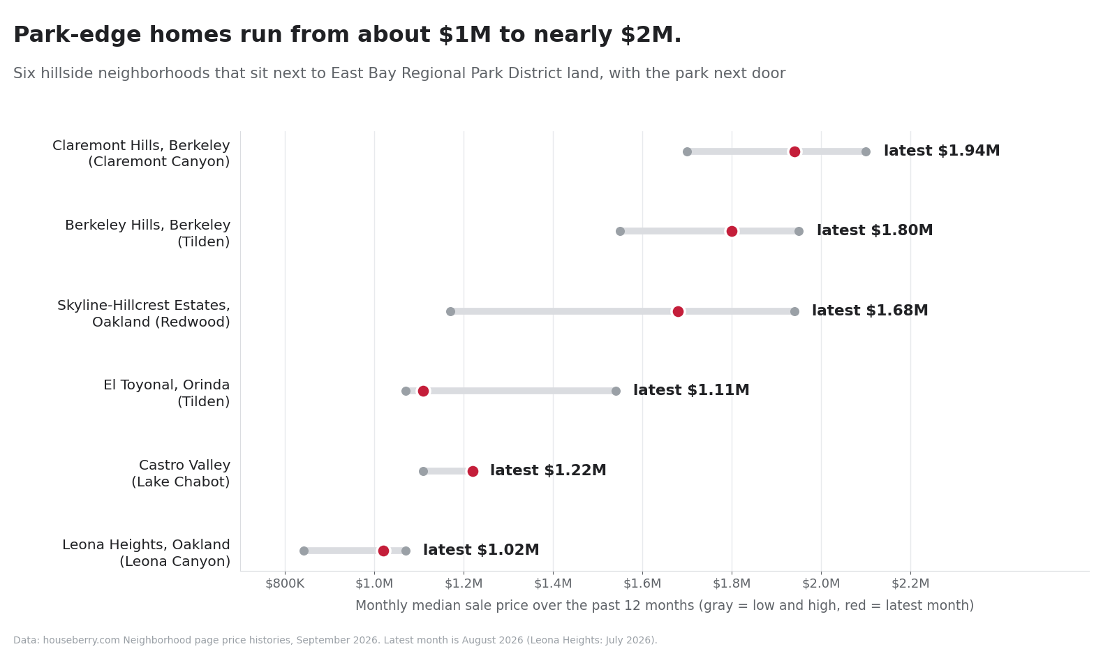
One caution about those numbers. These are small neighborhoods with few sales, so a single big house can swing a month. El Toyonal went from $1.54 million in May to $1.11 million in August. Look at the range, not one dot.
Will this lower my home insurance?
Not directly. California's Safer from Wildfires rules, which took effect in October 2022, require insurers to offer discounts for specific steps. Those steps are about your house, your yard and your block, not the park behind it.
The list covers things like a fire-rated roof, ember-resistant vents, clearing the first five feet around your house, and joining a community program such as Firewise USA. Insurers also have to tell you your wildfire risk score and let you appeal it. Fuel work on public park land is not one of the listed discounts.
That matters because costs are still climbing. The California FAIR Plan, the insurer of last resort, raises rates an average of 29.1 percent on October 15, 2026. Some lower-risk urban Bay Area areas may see decreases, while high-risk hillsides can see much bigger jumps. We walked through how that is spreading beyond the hills in our piece on Bay Area home insurance costs.
So the honest trade-off is this. A better-run park next door lowers the odds of a bad day, and that is worth a lot. It just will not show up as a line on your bill.
What a hillside homeowner can do this fall
The useful moves are small and mostly free.
- Look over your back fence. If you see dead trees or piled brush on park land near you, the district's fuels line is (510) 881-1833.
- Clear your first five feet. Move wood piles, dry plants and anything else that burns away from the walls. This is the zone insurers ask about.
- Ask your insurer two questions. What is my wildfire risk score, and which discounts am I missing?
- Talk to your neighbors. A Firewise USA group on your street counts toward discounts for everyone in it.
- Ask when the map will be public. The staff report gives no finish date, so a note to the park district now keeps the question alive.
If you are shopping for a hillside home, add one step to your tour. Check the address on CAL FIRE's hazard zone map, then get an insurance quote before you write an offer, not after. The park next door is a big part of why these streets cost what they do. We think about it the way we think about everything at Houseberry: the neighborhood first, then the house.
Sources
- CEQAnet, State Coastal Conservancy Notice of Exemption, SCH 2026090931 (Sept. 22, 2026)
- California State Coastal Conservancy, staff recommendation, EBRPD Wildfire Resilience augmentation (Sept. 17, 2026)
- California State Coastal Conservancy, September 2024 grant awards
- East Bay Regional Park District, RFP: Framework for Prioritization of Vegetation Management
- East Bay Regional Park District, Fuels Management
- East Bay Regional Park District, 667-acre fuels reduction project (Sept. 2025)
- East Bay Regional Park District, Tilden 2026 Major Fuels Reduction Projects
- East Bay Regional Park District, The Oakland Hills Firestorm
- California Department of Insurance, Safer from Wildfires
- California Department of Insurance, wildfire safety regulation release (Oct. 17, 2022)
- KQED, California FAIR Plan announces 29.1% rate hike (Aug. 2026)
- CAL FIRE Office of the State Fire Marshal, Fire Hazard Severity Zones
- Houseberry neighborhood pages and East Bay rankings, September 2026
Map of East Bay Neighborhoods
Loading map...
View Full Map
Top Neighborhoods in East Bay, CA





All information provided on this website including but not limited to - school ratings, safety, amenities, user opinions, and property data - is for general informational purposes only. We do not guarantee its reliability, accuracy, or completeness. Users should independently verify information and consult appropriate professionals as needed. By using this website, you agree Houseberry is not responsible for actions, decisions, or consequences arising from reliance on the information provided
houseberry.com - CA DRE# 01847391
 Bay East ©2025. CCAR ©2025. bridgeMLS ©2025. Information Deemed Reliable But Not Guaranteed. This information is being provided by the Bay East MLS, or CCAR MLS, or bridgeMLS. The listings presented here may or may not be listed by the Broker/Agent operating this website. This information is intended for the personal use of consumers and may not be used for any purpose other than to identify prospective properties consumers may be interested in purchasing. Data last updated at September 25, 2026 12:00 AM