High-speed rail wants a cheaper way over the hills from Gilroy
The High-Speed Rail Authority will restudy the 45 miles from Gilroy over Pacheco Pass, with options that cut 15.1 miles of tunnel to as little as 4. Here is what changes, what stays, and what Gilroy and Morgan Hill buyers should weigh.

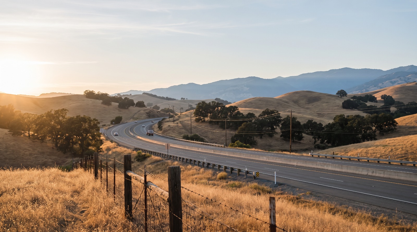
State Route 152 curving into the Diablo Range toward Pacheco Pass east of Gilroy at golden hour Photo: Houseberry
If you own a home in Gilroy or Morgan Hill, the high-speed rail plan for your town did not change this week. The station still goes downtown on Monterey Street in Gilroy. The tracks through Morgan Hill still follow the Caltrain line. What changed is the 45-mile climb east out of town, and with it, the honest answer to when a train might show up.
On October 13 the California High-Speed Rail Authority filed a notice that it will restudy the route from just south of Gilroy over the Diablo Range to the Central Valley. The approved plan from 2022 bores 15.1 miles of tunnel through Pacheco Pass. Three new options cut that to 10.7 miles, or to about 4. The state's CEQA summary of the project says the line would open on mostly one track in 2040 and reach two tracks by 2050.
This is a story about money. The Authority's own notice says the approved route costs more than its revenue forecasts can cover.
Three cheaper ways over the Diablo Range
The approved line leaves the Caltrain corridor south of Gilroy, crosses the Pajaro River floodplain and the wetland basin called Soap Lake, turns north at Casa de Fruta and follows Highway 152 through Pacheco Pass. Here is how the new options compare, from the table in the Authority's notice.
| Option | Tunnel | Elevated | Embankment | Total length |
|---|---|---|---|---|
| Alternative 4 (approved 2022) | 15.1 mi | 13.8 mi | 17.2 mi | 46.1 mi |
| Alternative 5 | 10.7 mi | 16.3 mi | 19.1 mi | 46.1 mi |
| Alternative 6 | about 4 mi | 11.1 mi | 30.4 mi | 45.5 mi |
| Alternative 7 | about 4 mi | 13.6 mi | 28.1 mi | 45.7 mi |
Alternative 5 is the same line drawn with a different profile. It trades about 4.4 miles of tunnel for more bridge and more earth berm.
Alternatives 6 and 7 are a different idea. They head through Soap Lake toward Dunneville, cross Highway 156 and the inner Coast Range, and pass northeast of Los Banos instead of hugging Highway 152. Alternative 7 comes in two versions, one swinging north by Comstock Road and one threading between San Luis and Los Banos reservoirs. All of them rejoin the approved route at both ends.
The other big change is the track. The first phase would be "a mostly single-track alignment with passing sidings in limited locations," in the notice's words, with a second track added later. A train every so often, waiting in a siding for the one coming the other way, is a long way from the system voters approved in 2008. It is also a train that can actually be paid for.
Why the Authority is backing away from the tunnels
The notice is blunt. Revenue forecasts "cannot accommodate the costs for Alternative 4" within the timeframe of the 2026 Business Plan, which the board adopted in June. It cites higher construction costs since 2022 and "recent diminished reliability for federal funding."
That last phrase is about July 2025, when the U.S. Department of Transportation pulled about $4 billion in grants. California dropped its lawsuit over the money in December. What the state has left, per the Legislative Analyst's Office, is about $39 billion in available funding plus $1 billion a year from the cap-and-invest program from 2030 through 2045.
Almost all of that goes to the Central Valley first. The 162-mile Merced to Bakersfield segment is estimated at about $36 billion, with service targeted for 2032 or 2033 depending on which document you read. The full San Francisco to Los Angeles line runs about $126 billion in the draft plan. The upgrade of the existing tracks between San Jose and Gilroy, $2 billion to $5 billion, is assumed to be built "by other entities" and sits outside the plan's costs entirely.
Cutting tunnel miles on paper is the cheapest engineering this project will ever do. We think the Authority is right to look.
Downtown Gilroy gets the station. Morgan Hill gets the trains
Nothing in this restudy moves the station. The board picked the downtown site at the existing Caltrain station, between 7th and 9th streets on Monterey, back in 2019. An October 2025 Authority fact sheet says early station planning with the city will feed into updates of Gilroy's downtown plan.
Houseberry ranks Downtown Gilroy 11th of the city's 11 scored neighborhoods, at 2.1 out of 5 overall, with a safety score of 1.7 and a school score of 2.3. Prices have been moving the other way. The typical Downtown Gilroy home sold for about $925,000 in September 2026, up from about $848,000 in October 2025. That 9.1 percent gain is the largest of any Gilroy neighborhood in Houseberry's 12-month price histories.
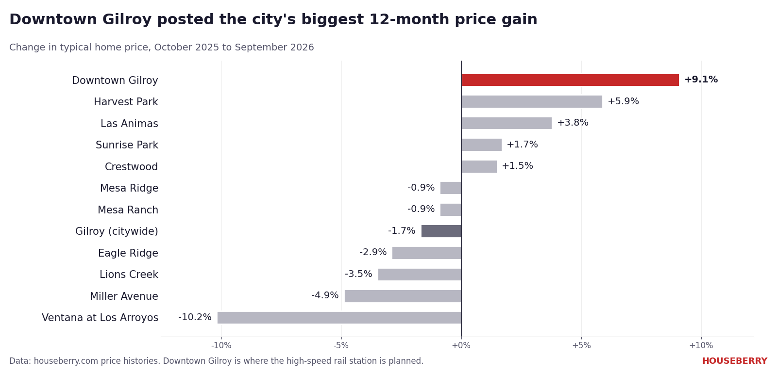
Citywide, Houseberry's Gilroy data shows the typical home at about $1.17 million in September 2026, down from about $1.19 million a year earlier. Downtown still costs about 21 percent less than the city overall.
We would not credit the train for any of that. A station that may open in 2040 does not show up in a 2026 sale price. Downtown Gilroy's homes are older than the subdivisions on the edges of town, and they have been one of the cheaper ways into a city where the newer subdivisions at Eagle Ridge top $1.7 million.
Morgan Hill sits on the San Jose to Gilroy stretch, which stays as approved: an at-grade, blended line on the existing Union Pacific and Caltrain tracks through downtown. The city asked for grade separations at East Dunne Avenue, Tennant Avenue and Tilton Drive in 2022. The board did not adopt them.
Houseberry's Morgan Hill data puts the typical home at about $1.53 million in September 2026, up from about $1.47 million a year earlier. Downtown Morgan Hill, the neighborhood the tracks run through, was about $910,000, and it slipped about 4 percent over the same 12 months.
The train that runs today is the one at risk
The real near-term question for South County rail is not 2040. It is November 3, 2026.
Caltrain runs four peak-direction round trips a weekday south of San Jose, on tracks Union Pacific owns, with no electrification past Tamien. Gilroy station averaged about 110 weekday riders in fiscal 2025. Caltrain projects a $75 million deficit, and VTA board member Pat Burt said South County service "would very much be on the table" if the regional sales tax measure on the November ballot fails, Mountain View Voice reported.
So the Gilroy buyer weighing a train is weighing two very different things: four commuter trips a day that could shrink next year, and a high-speed line that just admitted it needs a cheaper route to get built at all.
How to weigh in
The Authority holds scoping meetings on November 4 from 5:30 to 7 p.m. at Casa de Fruta's Orchard Room on Pacheco Pass Highway, on November 5 at the Los Banos Community Center, and online on November 9. None are in Gilroy. Written comments go to gilroy_wye@hsr.ca.gov with the subject line "G-Y Project Segment HSR Scoping Comment" by November 13, and the project page at hsr.ca.gov/GY has the maps.
A single track over the hills in 2040 is less than anyone was promised. It is more than an unfunded tunnel ever delivers. If you are deciding between the blocks near Monterey Street and the subdivisions on the edges of town, our Gilroy neighborhood ranking shows how all 11 compare today, train or no train.
Sources
- CEQAnet: Notice of Preparation, SCH 2009022083
- California High-Speed Rail Authority: Gilroy to Central Valley Wye project page
- High-Speed Rail Authority: 2022 approval of the San Jose to Merced section
- High-Speed Rail Authority: Gilroy station community
- Legislative Analyst's Office: Draft 2026 Business Plan
- Morgan Hill Times on the 2022 alignment vote
- Caltrain South County Connector
- Mountain View Voice on transit if the tax measure fails
The Houseberry Research Team is Houseberry's reporting team: Bay Area real estate analysts, data specialists and longtime local market watchers. Every day we check the public record: building permits, city council and planning agendas, county recorder filings, state housing bills, police incident data and school results. Then we tie each story to what it means for specific neighborhoods, using Houseberry's own neighborhood data on prices, appreciation, safety, schools and amenities. Questions or corrections: Contact us.
Map of Gilroy Neighborhoods
Loading map...
View Full Map
Top Neighborhoods in Gilroy, CA



All information provided on this website including but not limited to - school ratings, safety, amenities, user opinions, and property data - is for general informational purposes only. We do not guarantee its reliability, accuracy, or completeness. Users should independently verify information and consult appropriate professionals as needed. By using this website, you agree Houseberry is not responsible for actions, decisions, or consequences arising from reliance on the information provided
houseberry.com - CA DRE# 01847391
 Bay East ©2025. CCAR ©2025. bridgeMLS ©2025. Information Deemed Reliable But Not Guaranteed. This information is being provided by the Bay East MLS, or CCAR MLS, or bridgeMLS. The listings presented here may or may not be listed by the Broker/Agent operating this website. This information is intended for the personal use of consumers and may not be used for any purpose other than to identify prospective properties consumers may be interested in purchasing. Data last updated at October 18, 2026 12:00 AM