Sacramento levees passed the state audit. The Delta ones did not
The State Auditor rated 32 Central Valley levee agencies unacceptable. Sacramento's urban levee districts, from Natomas to the Pocket, are not among them. Who keeps which levee, and how to check your address.

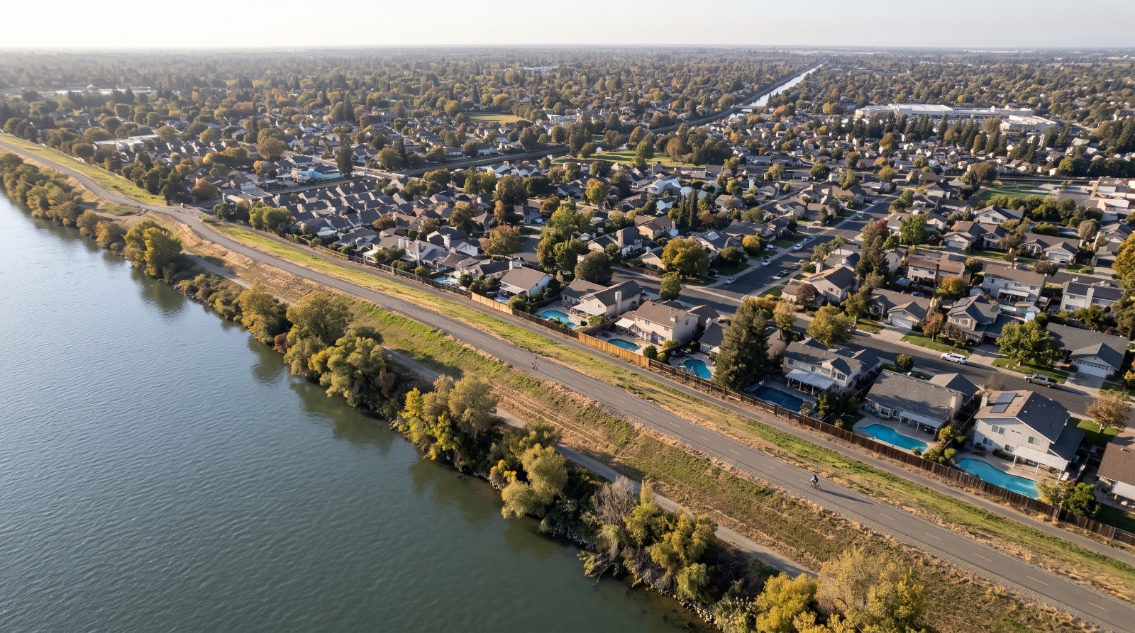
AI-rendered oblique aerial view of the Sacramento River east levee along the Pocket neighborhood in Sacramento, with homes below the levee crest Photo: Houseberry
California's State Auditor counted 133,030 buildings worth $38.9 billion behind levees whose local caretakers failed their state inspections. The Oct. 13 report found that the Department of Water Resources rated 32 of the 102 local agencies that maintain Central Valley levees "unacceptable" in 2025, and 23 of them had been unacceptable for at least five years. CalMatters put the story in front of the state on Oct. 21.
If you own a home in Natomas, the Pocket or River Park, read the list before you worry. None of the agencies that maintain Sacramento's urban levees is on it. The Sacramento County names are rural Delta districts, Sherman Island, Walnut Grove, Upper Andrus and Tyler Island, with about 4,400 residents between them.
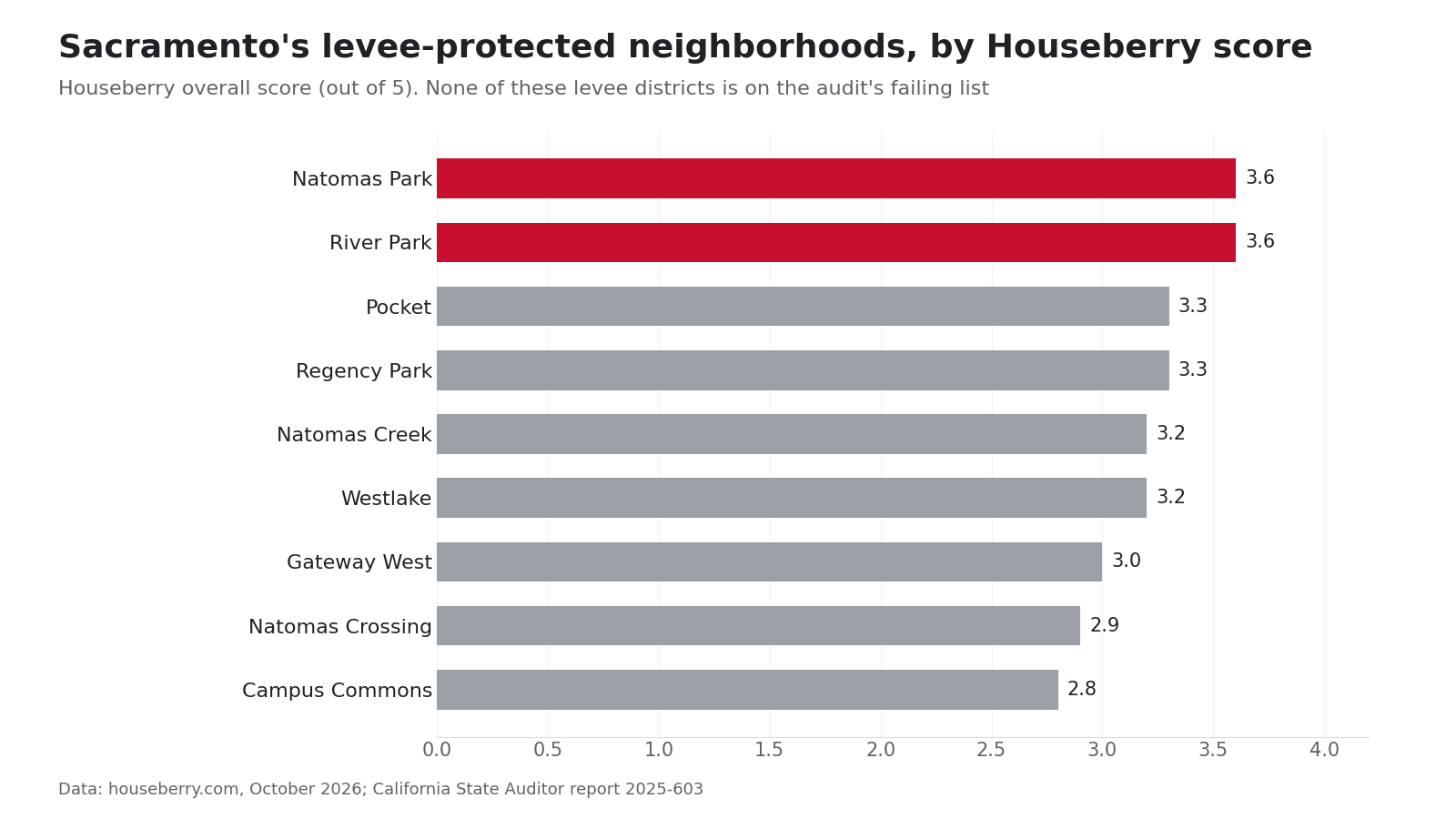
That matters for a lot of people. Natomas Park, one of two North Natomas neighborhoods in the top five of Houseberry's Sacramento rankings, scores 3.6 out of 5 and ranks 5th of 185. It sits inside a 42-mile levee ring the Army Corps of Engineers is still finishing.
Who keeps which Sacramento levee
Sacramento's city neighborhoods sit behind levees run by agencies that passed. Here is how the map breaks down, with each area's Houseberry overall score:
| Area | Levee system and caretaker | On the audit's failing list? | Houseberry neighborhood score |
|---|---|---|---|
| North Natomas | Natomas Basin ring, Reclamation District 1000 | No | Natomas Park 3.6, Westlake 3.2, Natomas Creek 3.2 |
| Pocket and Greenhaven | Sacramento River east levee, state Maintenance Area 9 | No | Pocket 3.3 |
| River Park and Campus Commons | American River levees, American River Flood Control District | No | River Park 3.6, Campus Commons 2.8 |
| West Sacramento | Reclamation District 900 and the city's flood agency | No | Not ranked |
| Walnut Grove, Sherman, Tyler and Andrus islands | Local reclamation districts 554, 341, 563 and 556 | Yes | Not ranked |
The Sacramento River's east bank from Sutterville Road south to Snodgrass Slough, the levee in front of the Pocket, Greenhaven and Freeport, is Maintenance Area 9, according to the county's local agency formation commission. It is not on the list. Neither is RD 1000 in Natomas.
River Park, along a bend of the American River, ties Natomas Park at 3.6 overall and scores 4.3 on safety in Houseberry's data. The Pocket, where the levee-top path is one of the neighborhood's draws, scores 3.3.
Natomas is safer than it was, and not finished
Natomas spent seven years unable to build. In December 2008, FEMA remapped the basin into a high-risk flood zone that required homes to be raised as much as 20 feet in places. On June 16, 2015, an A99 designation took effect, which lets building continue while the levees are upgraded. A99 still counts as high risk, the city says, and owners with federally backed mortgages must keep flood insurance until the work is complete.
The work is not complete. The Corps' project page lists the last reaches, along the East Main Drainage Canal, for the 2027 and 2029 construction seasons, and new pumping plants through 2027. Reach A, the Garden Highway stretch from Gateway Oaks to Farm Road, began construction in August 2022.
In the Pocket, erosion protection along the Sacramento River east levee began in 2022 and was expected to finish in 2026, the Central Valley Flood Protection Board said. Jet grouting ran under Garcia Bend Park in 2023 and 2024.
The money problem is everyone's problem
The audit's sharpest finding is about cash. The state bond money that paid for levee repairs, from 2006's Proposition 1E, is used up, and the state program that helped small districts pay for routine maintenance ended in the 2024-25 fiscal year. DWR disagreed with much of the report, writing that it "portrays a fundamental lack of understanding of the complexities of flood management."
We think the audit is right about the money and easy to misread on the map. A district like Sherman Island has 261 residents and 132 buildings, by the audit's count, and miles of levee to mow and patrol. It cannot carry that alone. But a failure in one district's levees can harm the whole basin, Yolo County's local agency formation commission told the auditor, and the Army Corps analyzes flood risk across the whole system. Sacramento owners have a stake in those rural levees even though their own passed.
How to check your own address
- Look up your parcel on FEMA's flood map service center or the state's MyHazards tool, which also models levee breaches.
- In the city, the floodplain team answers at 916-808-5061. In unincorporated Sacramento County, the flood zone hotline is 916-874-7517.
- Price flood insurance even outside a mapped zone. The federal program's Risk Rating 2.0 prices each home on its own elevation and distance to water, not just its zone. In unincorporated Sacramento County the average policy cost $460 in 2024, and only about 21.5 percent of properties in the high-risk zone carried one, the county's 2024 progress report said.
The audit gives DWR until January 2027 to name its repair sites and seek the money. Until then, the best comparison of what each levee-protected neighborhood offers is on Houseberry's Sacramento rankings, and you can find the levee closest to any address on the Houseberry map.
Sources
- California State Auditor, Report 2025-603, "State High-Risk Program: Poorly Maintained Dams and Levees Continue to Pose a Risk to Public Safety," Oct. 13, 2026, with Table C and fact sheet
- CalMatters, "Vital Central Valley flood control levees are poorly maintained, state watchdog finds," Oct. 21, 2026
- Sacramento LAFCo, maintenance districts
- City of Sacramento, Natomas flood maps
- U.S. Army Corps of Engineers, Natomas Basin and American River levee project pages
- Central Valley Flood Protection Board, Pocket area flood risk reduction project
- Sacramento County, 2024 Program for Public Information progress report
- Houseberry neighborhood scores, October 2026
The Houseberry Research Team is Houseberry's reporting team: Bay Area real estate analysts, data specialists and longtime local market watchers. Every day we check the public record: building permits, city council and planning agendas, county recorder filings, state housing bills, police incident data and school results. Then we tie each story to what it means for specific neighborhoods, using Houseberry's own neighborhood data on prices, appreciation, safety, schools and amenities. Questions or corrections: Contact us.
Map of Sacramento Neighborhoods
Loading map...
View Full Map
Top Neighborhoods in Sacramento, CA




All information provided on this website including but not limited to - school ratings, safety, amenities, user opinions, and property data - is for general informational purposes only. We do not guarantee its reliability, accuracy, or completeness. Users should independently verify information and consult appropriate professionals as needed. By using this website, you agree Houseberry is not responsible for actions, decisions, or consequences arising from reliance on the information provided
houseberry.com - CA DRE# 01847391
 Bay East ©2025. CCAR ©2025. bridgeMLS ©2025. Information Deemed Reliable But Not Guaranteed. This information is being provided by the Bay East MLS, or CCAR MLS, or bridgeMLS. The listings presented here may or may not be listed by the Broker/Agent operating this website. This information is intended for the personal use of consumers and may not be used for any purpose other than to identify prospective properties consumers may be interested in purchasing. Data last updated at October 22, 2026 12:00 AM