Thanksgiving king tides: the Bay Area roads that go underwater
This week's tides closed Miller Avenue, Lucky Drive and Shoreline Highway in Marin. Here are the roads that flooded, the Thanksgiving week tide times and the hours we would stay off them.

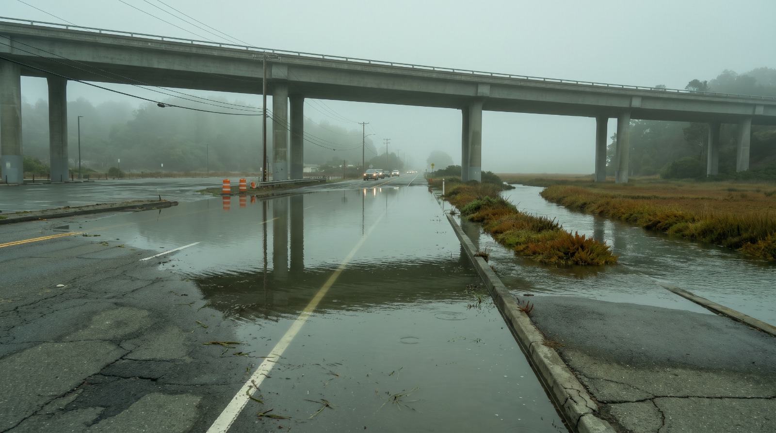
AI-rendered view of king tide water spilling across Shoreline Highway and the park-and-ride lot under Highway 101 at Manzanita in Mill Valley on a foggy morning Photo: Houseberry
Miller Avenue in Mill Valley closed to seawater between Camino Alto and Almonte Boulevard on at least three days this week. The sky was clear. A firefighter carried a woman out of a car that stalled in seawater, and kayakers paddled the bike path through Bothin Marsh. Down the road, Shoreline Highway went under at Manzanita, where it passes beneath Highway 101 just below Tam Junction, the crossroads Houseberry ranks second in Marin, with a 5.0 safety score.
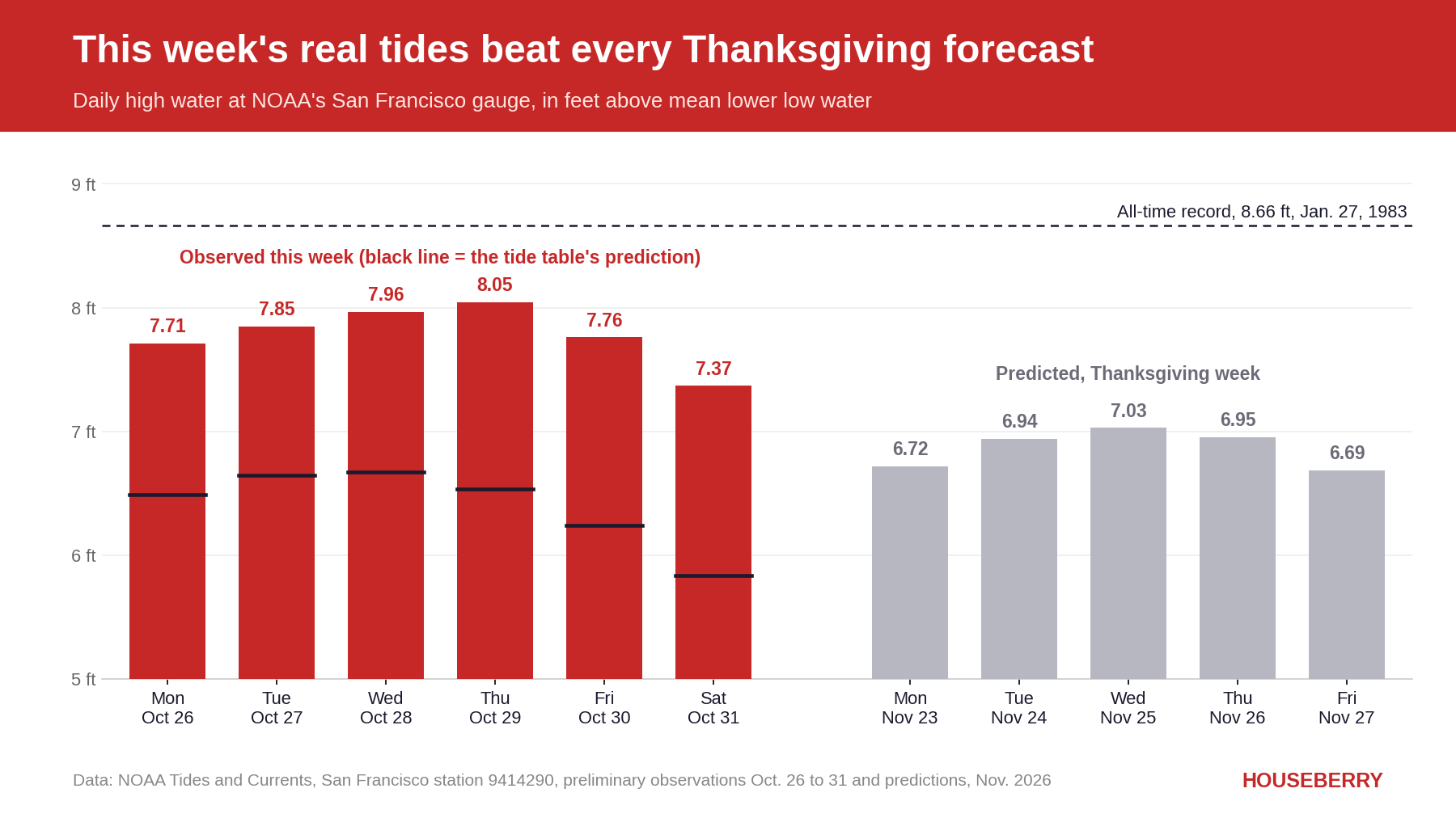
No storm did this. NOAA's San Francisco tide gauge ran 1.2 to 1.5 feet above its own tide table every day from Oct. 26 to 31 and peaked at 8.05 feet on Thursday. That is higher than any tide printed for Thanksgiving week, when the season's first official king tides arrive Nov. 24 to 26. This guide covers which roads and paths flooded, the hour the water arrives, and how to plan a holiday drive around it.
Sunday afternoon brings this round's last flooding tide
The weather service's Saturday evening advisory expects the San Francisco gauge to reach 6.8 feet at 3:59 p.m. Sunday, a foot above normal, with "isolated road closures" possible and "more substantial impacts" along bayshore Marin. Clocks fall back overnight, so every Sunday time here is standard time.
The water peaks later as you move away from the Golden Gate. NOAA's predictions put Sunday's high at about 4:09 p.m. in Sausalito, 4:31 p.m. in Alameda, 4:56 p.m. at Redwood City and 5:01 p.m. at Point San Pedro off San Rafael. The advisory ends at 6 p.m. On the ocean side, a beach hazards statement for sneaker waves runs from late Sunday night through Tuesday.
The roads that went under this week
Marin took nearly all of it. Rachel Kennedy, a weather service meteorologist, called the county a flooding "hotspot" in KQED's Oct. 29 report, and San Rafael planner Kate Hagemann told KQED that a large part of her city sits lower than the bay.
The table pulls from police alerts, the weather service's storm reports and local TV, matched to the Houseberry neighborhood each spot sits in or borders. That puts Miller Avenue's closed stretch at the edge of Almonte, the Manzanita lot between Tam Junction and Marin City, Doherty Drive in South Larkspur, Lucky Drive on the line between it and Corte Madera, and Mariner Cove inside Corte Madera. The last column is our window for Wednesday, Nov. 25, explained below.
| Road or path | Houseberry neighborhood | Flooded this week | Stay off Wed, Nov. 25 |
|---|---|---|---|
| Shoreline Highway under Highway 101, and the Manzanita park-and-ride | Tam Junction, Marin City | Oct. 26 and 27 | 10 a.m. to 2 p.m. |
| Miller Avenue, Camino Alto to Almonte Boulevard | Almonte | Oct. 26, 27 and 29 | 10 a.m. to 2 p.m. |
| Mill Valley-Sausalito Path at Bothin Marsh | Almonte | Oct. 26 to 29 | 10 a.m. to 2 p.m. |
| Redwood Highway frontage road, Hamilton Drive to the southbound Seminary Drive ramps | Strawberry, across 101 | Oct. 26, 27 and 29 | 10 a.m. to 2 p.m. |
| Highway 101 ramps in north Sausalito | Marinship | Oct. 26 to 29 | 10 a.m. to 2 p.m. |
| Lucky Drive and its southbound 101 off-ramp | South Larkspur, Corte Madera | Oct. 26 to 30 | 11 a.m. to 3 p.m. |
| Golden Hind Passage, Fifer Avenue, Tamal Vista Boulevard | Corte Madera | Oct. 27 to 30 | 11 a.m. to 3 p.m. |
| Doherty Drive at Riviera Circle, Larkspur Plaza Drive | South Larkspur | Oct. 29 | 11 a.m. to 3 p.m. |
| Southbound 101 off-ramp at Irwin Street | Downtown San Rafael | Oct. 27 | 11 a.m. to 3 p.m. |
| Embarcadero sidewalk and bike lane at Pier 14 | South Beach | Oct. 26 and 27 | 10 a.m. to 2 p.m. |
Lucky Drive was underwater for the fifth day this week on Friday, and Corte Madera issued its first $100 citation for going around a road closure, ABC7 reported. In Mariner Cove, off Golden Hind Passage, the water was knee-deep in spots.
Across the bay the list thins out. Besides Pier 14, the weather service's only Bay report outside Marin was the walking paths at the Palo Alto Baylands, where TV video showed the water arriving faster than expected. We found no road closures reported in Alameda, Foster City or Redwood Shores this week.
Thanksgiving week depends on the extra foot
The printed tides for Thanksgiving week look tamer. NOAA predicts 6.94 feet at San Francisco at 10:05 a.m. Tuesday, Nov. 24, then 7.03 feet at 10:49 a.m. Wednesday and 6.95 feet at 11:38 a.m. on Thanksgiving Day. Every high tide from Oct. 26 to 31 beat all three.
The gap is ocean the table does not know about. El Niño has warmed and expanded the water off California, and on Oct. 26 the gauge set its highest October reading on record, 1.87 feet above an average high tide, CBS reported. Kennedy told KQED the warm water "has been helping keep the water a bit higher than initially forecast."
Add this week's 1.2 to 1.5 feet to Wednesday's 7.03 and you get 8.2 to 8.5 feet, within about 2 to 5 inches of the 1983 record. That is arithmetic, not a forecast. The extra water comes in pulses and could be smaller by then, or a storm could add more. Climate scientist Daniel Swain of UC Agriculture and Natural Resources told KQED he sees a "very high likelihood" of widespread coastal flooding around Thanksgiving and Christmas.
Our view: read every printed tide this winter as a foot low.
Even without the extra foot, some of these spots flood. Marin County's own tide notices treat a predicted San Francisco high of about 6.3 to 6.4 feet as enough to flood Lucky Drive, Marin City and the Manzanita lot, and Thanksgiving week has five days above 6.5 feet, Nov. 23 through 27. Caltrans closed the lower half of the Manzanita park-and-ride around the clock from Nov. 25 to Dec. 8 last year.
There is an earlier date to watch, too. The table shows 6.24 feet at 10:06 a.m. on Nov. 8. Add this week's gap and it lands at 7.4 to 7.7 feet, close to the 7.71 feet that flooded Miller Avenue on Monday.
How to time a drive around the tide
On Tuesday, Oct. 27, the San Francisco gauge peaked at 12:24 p.m. Mill Valley police closed Miller Avenue around noon and reopened it shortly before 4 p.m., and the Lucky Drive off-ramp closed at 2:15 p.m. The water reaches the low Marin roads near the local high tide and drains back out slowly.
So our rule of thumb is one hour before the nearest gauge's high tide to three hours after. Use the gauge closest to the road.
| NOAA gauge | Use it for | Tue, Nov. 24 | Wed, Nov. 25 | Thu, Nov. 26 |
|---|---|---|---|---|
| San Francisco | The Embarcadero | 10:05 a.m. | 10:49 a.m. | 11:38 a.m. |
| Sausalito | Sausalito, Mill Valley, Tam Junction | 10:15 a.m. | 10:59 a.m. | 11:48 a.m. |
| Point San Pedro | Corte Madera, Larkspur, San Rafael | 11:07 a.m. | 11:51 a.m. | 12:40 p.m. |
| Alameda | Alameda and the Oakland shore | 10:36 a.m. | 11:21 a.m. | 12:10 p.m. |
| Redwood City | The Peninsula bayfront | 11:02 a.m. | 11:46 a.m. | 12:35 p.m. |
The window slides about 45 minutes later each day. If you are driving out of Tam Valley on Wednesday, go before 10 a.m. or after 2 p.m. On Thanksgiving Day the southern Marin window runs from about 10:45 a.m. to 2:45 p.m., which covers a midday drive to dinner. Six inches of water can stall a car, Marin County warns, and Corte Madera is now writing tickets to drivers who go around the barricades.
What our scores do not measure
Houseberry scores neighborhoods on schools, safety and amenities. Tidal flooding is not in the score, and this week shows why a buyer has to check it separately. The eight Marin neighborhoods next to a tide-closed road average 4.0 on our overall score, slightly above the 3.9 average for the 55 scored neighborhoods on Houseberry's Marin ranking, by our count in November 2026. Three of them, Tam Junction, Almonte and Corte Madera, sit in Marin's top 10.
Our October overlay of FEMA flood zones put 92 percent of Tam Junction's land in the 1 percent annual chance zone, along with 48.5 percent of South Larkspur and 43 percent of Corte Madera. These are not cheap places. In September 2026 the typical home ran about $1.21 million in Marin City, $1.78 million in Corte Madera and $2.34 million in South Larkspur, according to Houseberry's price history. A street can be a good place to live and still go under a few mornings each winter.
Our September look at the king tide dates said the late October tides were the sleeper. They were. If you are shopping near the water, compare the shoreline towns on Houseberry's Marin neighborhood ranking, then stand on the lowest street of the one you like at 11 a.m. on Nov. 25.
Sources
- National Weather Service San Francisco Bay Area: Coastal Flood Advisory, Oct. 31, 2026 (archived text)
- NOAA Tides and Currents: San Francisco station 9414290 observations and predictions
- Patch: Tidal flooding continues to close roads across Marin County, Oct. 29, 2026
- NBC Bay Area: High tide flooding causes road closures in Mill Valley, Oct. 27, 2026
- CBS San Francisco: San Francisco high tide sets October record, Oct. 27, 2026
- KQED: Marin is the hotspot, Oct. 29, 2026
- KQED: San Francisco Embarcadero floods as tides peak 2 feet above normal, Oct. 27, 2026
- ABC7: More flooding expected after high tides cause issues in Marin County, Oct. 30, 2026
- Marin County Public Works: tide-related flooding notice and flood-prone roads
- Caltrans District 4: Manzanita park-and-ride high tide closure, Nov. 10, 2025
- California Coastal Commission: King Tides Project dates
The Houseberry Research Team is Houseberry's reporting team: Bay Area real estate analysts, data specialists and longtime local market watchers. Every day we check the public record: building permits, city council and planning agendas, county recorder filings, state housing bills, police incident data and school results. Then we tie each story to what it means for specific neighborhoods, using Houseberry's own neighborhood data on prices, appreciation, safety, schools and amenities. Questions or corrections: Contact us.
Map of Marin Neighborhoods
Loading map...
View Full Map
Top Neighborhoods in Marin, CA





All information provided on this website including but not limited to - school ratings, safety, amenities, user opinions, and property data - is for general informational purposes only. We do not guarantee its reliability, accuracy, or completeness. Users should independently verify information and consult appropriate professionals as needed. By using this website, you agree Houseberry is not responsible for actions, decisions, or consequences arising from reliance on the information provided
houseberry.com - CA DRE# 01847391
 Bay East ©2025. CCAR ©2025. bridgeMLS ©2025. Information Deemed Reliable But Not Guaranteed. This information is being provided by the Bay East MLS, or CCAR MLS, or bridgeMLS. The listings presented here may or may not be listed by the Broker/Agent operating this website. This information is intended for the personal use of consumers and may not be used for any purpose other than to identify prospective properties consumers may be interested in purchasing. Data last updated at November 2, 2026 12:00 AM