Where to Trick-or-Treat in the Bay Area: Best Neighborhoods
The Bay Area neighborhoods that actually draw the Halloween crowds, city by city, matched to Houseberry's neighborhood pages, with 2025 street-closure hours, transit and timing tips, and each neighborhood's safety and overall scores.
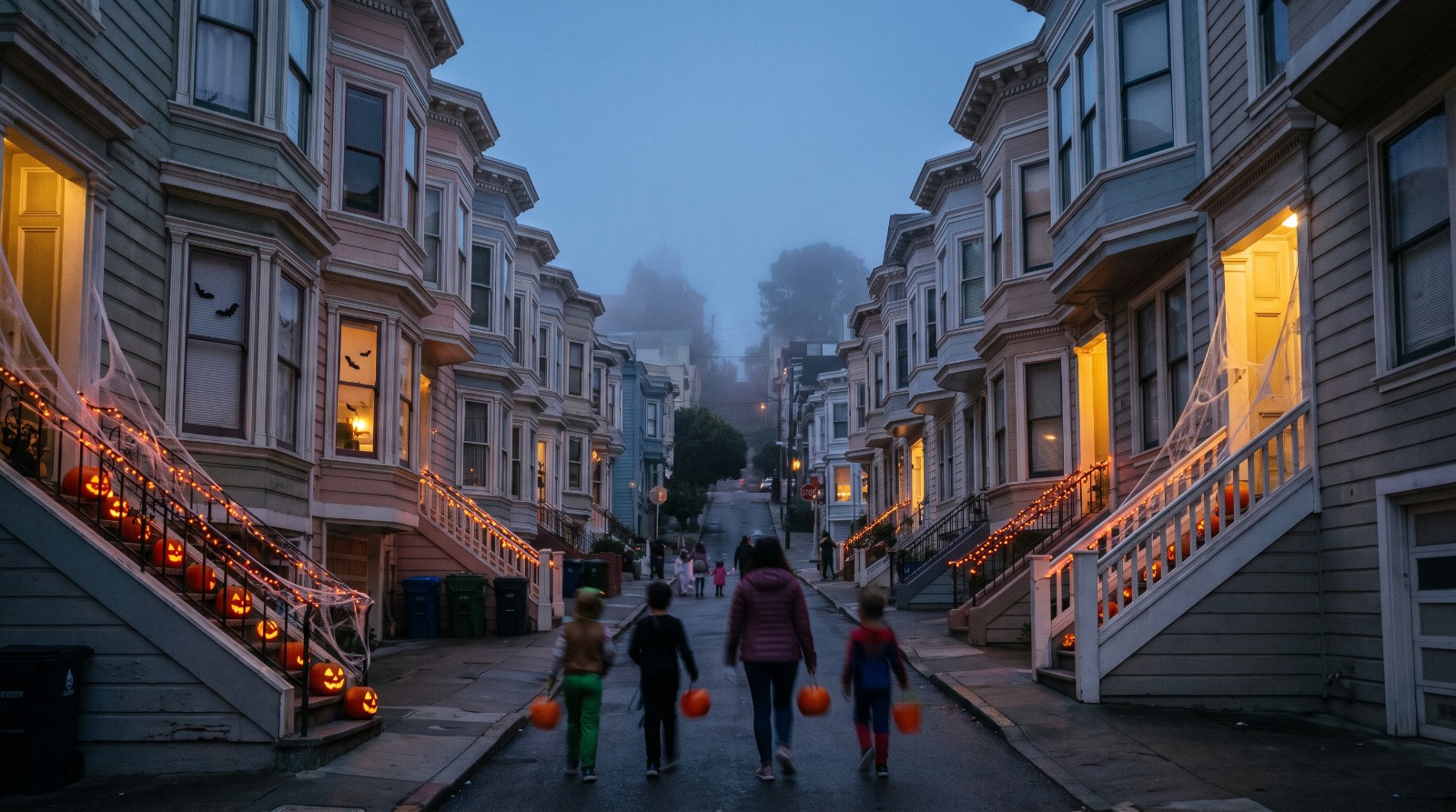
Halloween trick-or-treaters walking up a San Francisco street of Victorian houses with glowing jack-o'-lanterns, one of the best Bay Area trick-or-treat neighborhoods Photo: Houseberry
Every October the same question lands in my group chats, usually from someone who just moved to a condo or a street with three porches on it: where do people actually go? The honest answer is that Bay Area Halloween runs on a few dozen specific blocks, and most of them are in neighborhoods you can name.
The best trick-or-treat neighborhoods in the Bay Area for Halloween 2026 are Cole Valley/Parnassus Heights, Noe Valley, Jordan Park / Laurel Heights and Sea Cliff in San Francisco, Crocker Highlands and Rockridge in Oakland, Elmwood in Berkeley, Easton Addition in Burlingame, Willow Glen in San Jose, and Downtown Los Gatos. What they share is not a high score. It is houses packed close to the sidewalk, flat or gentle blocks, and neighbors organized enough to close a street.
Halloween falls on Saturday, October 31, 2026, so there is no school-night curfew this year. Expect the famous blocks to fill early.
What makes a block good for trick-or-treating
A good trick-or-treat block is one where a small person can hit 20 doors in 10 minutes without crossing a busy street. That comes down to lot size, stairs, terrain and whether someone on the block filed for a closure.
That is why this list looks different from our usual rankings. Sea Cliff and Jordan Park / Laurel Heights sit in the top five of our San Francisco neighborhood rankings, and they are great Halloween spots. But so is Bernal Heights at 73rd, because Cortland Avenue and three side streets go car-free every year. When we look at a neighborhood for daily life, schools and safety carry weight. On October 31, the physical layout of the blocks matters most.
Every name below matches the neighborhood's page on Houseberry, and where a famous street sits inside a neighborhood with a different name, I name both. Scores come from our neighborhood rankings as of September 2026.
San Francisco: the city of closed streets
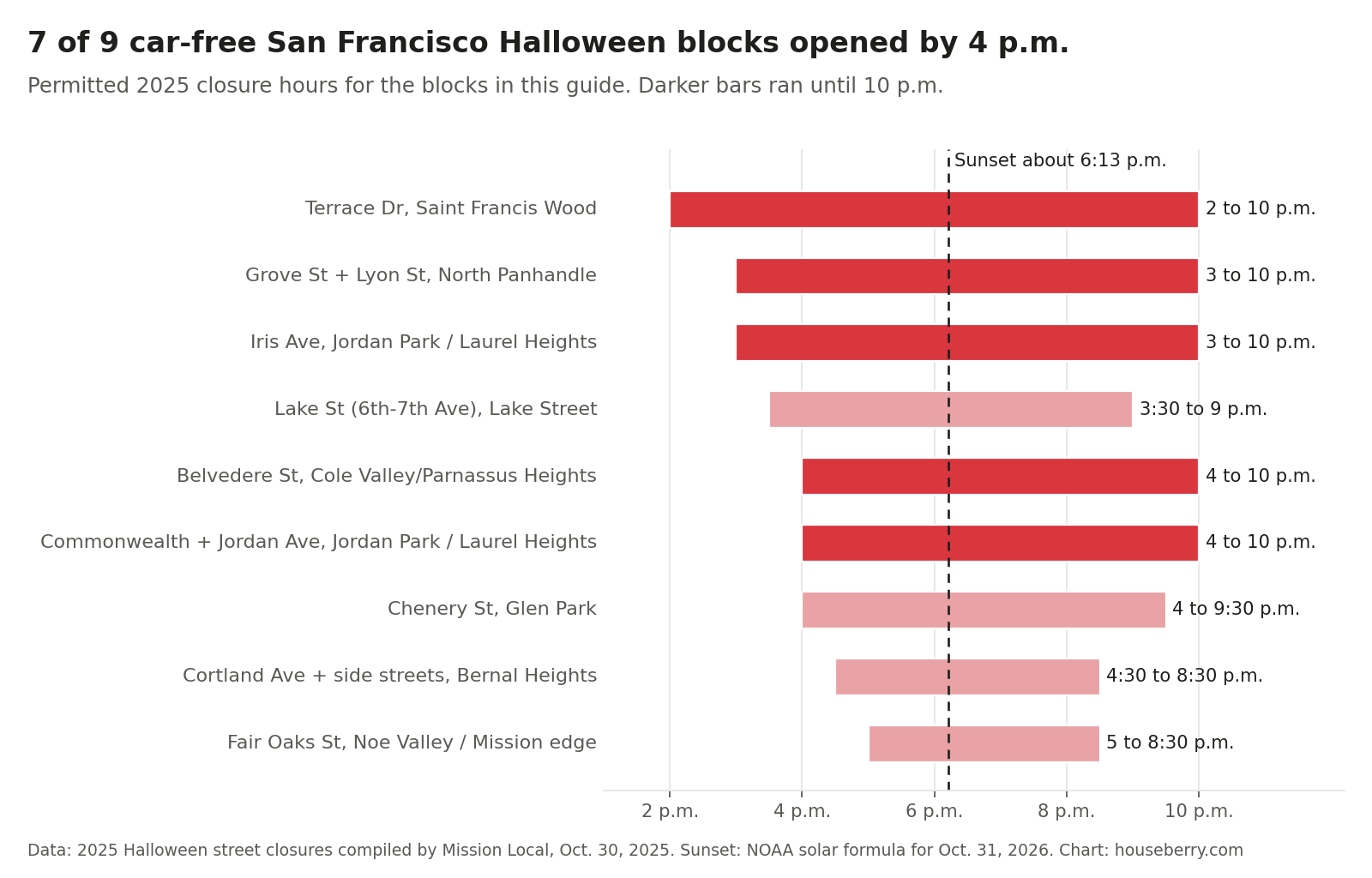
San Francisco does Halloween by permit. In 2025 the city had car-free Halloween closures on more than 40 street segments, from Terrace Drive in Saint Francis Wood to 45th Avenue in the Outer Sunset, Mission Local reported on October 30. The 2026 list usually surfaces in the last week of October, so treat last year's hours below as a guide, not a promise.
Cole Valley/Parnassus Heights: Belvedere Street
Belvedere Street between Parnassus Avenue and 17th Street is the city's best-known Halloween block, a steep run of Victorians that climbs from Cole Valley/Parnassus Heights toward Ashbury Heights. In 2025 it was closed to cars from 4 to 10 p.m., and Shrader Street between Frederick and Beulah closed from 3 to 10 p.m. The SF Standard's guide puts it bluntly: go early and expect crowds. Candy runs out on the popular houses, per Mommy Poppins.
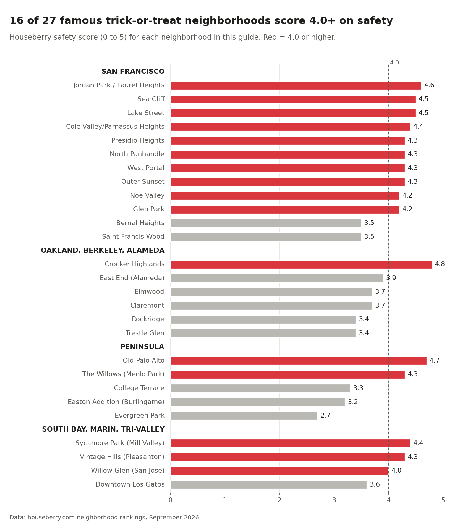
Take the N Judah to Carl and Cole and walk up. The neighborhood scores 4.1 overall and 4.4 on safety. The trade-off is the hill. Belvedere is a climb, and the stoops are tall.
Noe Valley: 24th Street and the flat blocks
Noe Valley is the flat-blocks pick. SFGate describes the parade of costumed toddlers along 24th Street between Church and Castro starting around 3 p.m., and the side streets are flatter than most of the city. Fair Oaks Street, just across Dolores on the Mission side, closed from 22nd to 26th streets from 5 to 8:30 p.m. in 2025.
Noe Valley scores only 3.2 overall, 61st of 92 in San Francisco, mostly because of school scores. Its safety score is 4.2. On Halloween, that overall number is irrelevant. The J Church stops at 24th Street.
Jordan Park / Laurel Heights and Presidio Heights
Jordan Park / Laurel Heights quietly runs one of the biggest closure clusters in the city. Commonwealth Avenue and Jordan Avenue were car-free from California to Geary from 4 to 10 p.m. in 2025, and Iris Avenue from 3 to 10 p.m. The streets are wide and flat. It is also our top-ranked San Francisco neighborhood, at 4.2 overall and 4.6 on safety.
Next door, Presidio Heights (4.2 overall, 4.3 safety) works as a loop: Sacramento Street merchants, then Washington Street and the Presidio Terrace cul-de-sac off Arguello, the route the SF Standard recommends.
Sea Cliff and Lake Street
Sea Cliff has the full-size-candy-bar reputation, and several hundred trick-or-treaters show up each year, according to Mommy Poppins. Bay City News found the heaviest decorating between 28th and 32nd avenues in 2025, per Local News Matters. If the core gets too packed, the Standard suggests staying near California Street and 32nd Avenue.
A few blocks east, Lake Street is both a Houseberry neighborhood and a Slow Street. The 5th-to-9th Avenue and 23rd-to-25th Avenue stretches draw the crowds, and the block between 6th and 7th avenues closed from 3:30 to 9 p.m. in 2025. Both neighborhoods score 4.5 on safety.
North Panhandle, Glen Park and Bernal Heights
These three are the block-party neighborhoods. In North Panhandle, Grove Street between Baker and Central and Lyon Street between Fulton and Hayes closed from 3 to 10 p.m. in 2025, and the 1500 and 1600 blocks of Grove host a kids' costume contest and a haunted house.
Glen Park closes Chenery Street between Elk and Diamond, 4 to 9:30 p.m. last year, and Glen Park BART is a block away. In Bernal Heights, Cortland Avenue from Bennington to Gates plus Moultrie, Anderson and Ellsworth streets went car-free from 4:30 to 8:30 p.m. Glen Park scores 4.2 on safety. Bernal Heights scores 3.5.
West Portal, Saint Francis Wood and the Outer Sunset
West Portal has had a Wawona Street block party since the 1980s, per Mommy Poppins, a short walk from West Portal Station. Wawona did not appear on Mission Local's 2025 closure list, so check before you count on it. Saint Francis Wood closed Terrace Drive from Portola to Santa Clara for the longest window on the list, 2 to 10 p.m.
The Outer Sunset had more separate closures than any other area in 2025, including 36th, 42nd, 43rd and 45th avenues. It scores 4.2 overall and 4.3 on safety, second in the city overall.
Oakland, Berkeley and Alameda: the porch-dense East Bay
The inner East Bay's Halloween map is short and well known. These blocks pull people from all over the region, so arrive before dusk if you want a parking spot.
Crocker Highlands and Trestle Glen
Trestle Glen Road east of Lakeshore Avenue is Oakland's densest trick-or-treat corridor. Red Oak Realty notes the houses sit close together and the street gets crowded. The road runs through two Houseberry neighborhoods: Crocker Highlands, which is first of 130 Oakland neighborhoods at 4.3 overall and 4.8 on safety, and Trestle Glen, at 3.5 overall and 3.4 on safety.
Haddon Hill, the cluster of big houses with decorated stoops and front-yard graveyards near Lake Merritt, is also on every list. We do not map it as its own neighborhood, so start from our Oakland neighborhood rankings if you are looking at homes there.
Rockridge
Rockridge does two Halloweens. The merchant parade and trick-or-treat on College Avenue ran from Broadway to Alcatraz on the Sunday before Halloween in 2025, starting at the Rockridge BART plaza, per 510 Families. On the night itself, parents on the Berkeley Parents Network point to Boyd Avenue between Hudson and Clifton. Rockridge scores 3.8 overall, 3.4 on safety and 4.6 on amenities.
Elmwood and Claremont: Russell Street
Russell Street from College Avenue up to the Claremont Hotel is Berkeley's big one, with elaborate yard graveyards and haunted houses, per SFGate. It starts in Elmwood and climbs into Claremont, both 3.9 overall and 3.7 on safety. The Claremont Elmwood Neighborhood Association sponsors it, and the City Council approved up to $1,000 per council office toward the 2025 event, calling it one of the best trick-or-treat spots in Berkeley in the council item. Take younger kids early. Crowds peak after sunset.
Alameda: the Gold Coast and the East End
Alameda's Gold Coast is the region's biggest single draw. One resident near Grand and Paru streets estimated about 2,500 visitors at his corner and gave out 5,700 pieces of candy, the Standard reported on October 31, 2025. Families come from Oakland and San Francisco for the flat, lit streets. We map Alameda's main island as two large neighborhoods, West End and East End, rather than using the Gold Coast name, so check the Alameda rankings for the blocks you care about.
In the East End (4.1 overall, 3.9 on safety), Berkeley Parents Network regulars send people to Thompson Avenue between High Street and Fernside Boulevard.
The Peninsula: fewer blocks, bigger candy budgets
The Peninsula's famous Halloween streets are narrower and more residential, and the numbers can be startling.
Easton Addition, Burlingame: Cabrillo Avenue
Five blocks of Cabrillo Avenue between Adeline Drive and Carmelito Avenue in Easton Addition are the Peninsula's headline block. One family told the Burlingame B it buys 20,000 pieces of candy a year. SFGate points out the flat street and close-together houses with no stairs. Easton Addition scores 4.0 overall, with a 4.8 school score and 3.2 on safety.
Old Palo Alto, College Terrace and Evergreen Park
Old Palo Alto is big enough on Halloween that Palo Alto Online has run traffic advisories about streets closing there. It scores 4.6 overall and 4.7 on safety. In Evergreen Park, residents told Palo Alto Online their count went from zero to hundreds in a few years, and a College Terrace resident described hundreds of kids coming through. Both neighborhoods lean on the Nextdoor treat map.
The Willows, Menlo Park
Pope Street in The Willows shows up in both Mommy Poppins and Silicon Valley agent roundups, with the same advice: bring little kids early. The Willows scores 4.3 overall and 4.3 on safety.
South Bay, Marin and the Tri-Valley
Willow Glen, San Jose
Willow Glen is San Jose's Halloween center. The Willow Glen Business Association's daytime trick-or-treat along Lincoln Avenue ran from Minnesota Avenue to Willow Street in 2025, with a toddler session from 11 a.m. and a school-age session from 3 to 4:30 p.m., per a local agent's recap. The flat grid of bungalows around Lincoln carries the evening. Willow Glen scores 3.7 overall and 4.0 on safety. Naglee Park near downtown also appears in Silicon Valley agent roundups, though our scores for it are still in progress.
Downtown Los Gatos: Tait Avenue in Almond Grove
Tait Avenue, from West Main Street to Los Gatos-Saratoga Road in the historic Almond Grove area of Downtown Los Gatos, closes to cars for the night. Residents have historically handed out 1,000 to 2,000 pieces of candy each, the Los Gatan reported in 2025. The neighborhood scores 4.1 overall and 3.6 on safety.
Sycamore Park, Mill Valley, and Vintage Hills, Pleasanton
Mill Valley closed Sycamore Avenue from Park Avenue to Valley Circle and Walnut Avenue from Park to Locust for Halloween 2025, the city's newsletter said. Those streets sit in the flat, sidewalked part of town Houseberry maps as Sycamore Park, 4.5 overall and 4.4 on safety.
In the Tri-Valley, Vintage Hills east of downtown Pleasanton made Bay Area Telegraph's 2025 list for walkable streets and high participation. It scores 4.3 overall and 4.3 on safety.
Every neighborhood in this guide, side by side
Here is the full list with the street that draws the crowd and the two Houseberry scores most people ask about.
| City | Houseberry neighborhood | Halloween stretch | Overall | Safety |
|---|---|---|---|---|
| San Francisco | Cole Valley/Parnassus Heights | Belvedere St, Shrader St | 4.1 | 4.4 |
| San Francisco | Noe Valley | 24th St, Church to Castro | 3.2 | 4.2 |
| San Francisco | Jordan Park / Laurel Heights | Commonwealth, Jordan and Iris aves | 4.2 | 4.6 |
| San Francisco | Presidio Heights | Sacramento St, Presidio Terrace | 4.2 | 4.3 |
| San Francisco | Sea Cliff | 28th to 32nd aves | 4.2 | 4.5 |
| San Francisco | Lake Street | Lake St Slow Street | 4.1 | 4.5 |
| San Francisco | North Panhandle | Grove St, Lyon St | 4.0 | 4.3 |
| San Francisco | Glen Park | Chenery St | 3.3 | 4.2 |
| San Francisco | Bernal Heights | Cortland Ave and side streets | 2.8 | 3.5 |
| San Francisco | West Portal | Wawona St | 3.8 | 4.3 |
| San Francisco | Saint Francis Wood | Terrace Dr | 3.5 | 3.5 |
| San Francisco | Outer Sunset | 36th to 45th aves | 4.2 | 4.3 |
| Oakland | Crocker Highlands | Trestle Glen Rd | 4.3 | 4.8 |
| Oakland | Trestle Glen | Trestle Glen Rd | 3.5 | 3.4 |
| Oakland | Rockridge | College Ave, Boyd Ave | 3.8 | 3.4 |
| Berkeley | Elmwood | Russell St | 3.9 | 3.7 |
| Berkeley | Claremont | Russell St | 3.9 | 3.7 |
| Alameda | East End | Thompson Ave | 4.1 | 3.9 |
| Burlingame | Easton Addition | Cabrillo Ave | 4.0 | 3.2 |
| Palo Alto | Old Palo Alto | Neighborhood-wide | 4.6 | 4.7 |
| Palo Alto | College Terrace | Neighborhood-wide | 4.0 | 3.3 |
| Palo Alto | Evergreen Park | Neighborhood-wide | 3.6 | 2.7 |
| Menlo Park | The Willows | Pope St | 4.3 | 4.3 |
| San Jose | Willow Glen | Lincoln Ave and side streets | 3.7 | 4.0 |
| Los Gatos | Downtown Los Gatos | Tait Ave | 4.1 | 3.6 |
| Mill Valley | Sycamore Park | Sycamore Ave, Walnut Ave | 4.5 | 4.4 |
| Pleasanton | Vintage Hills | Neighborhood-wide | 4.3 | 4.3 |
Seven of the 12 San Francisco neighborhoods rank in the city's top 20 overall. Three rank below 50th. And two of the East Bay's busiest Halloween destinations, Russell Street and the Gold Coast, sit in neighborhoods scoring under 4.0 on safety. On Halloween night, closed streets and a lot of people outside do much of the work.
Timing, parking and getting there
Go before dark if your kids are small. With sunset around 6:13 p.m. on October 31, 2026, the 4:30 to 6 p.m. window gives you daylight, shorter lines and houses that still have candy. The famous blocks get loud and packed after dusk, especially on a Saturday.
Take transit where you can. The N Judah drops you at Cole Valley, the J Church at 24th Street in Noe Valley, BART at Glen Park and Rockridge, and Muni Metro at West Portal Station. Parking near Belvedere, Russell Street, the Gold Coast and Cabrillo Avenue fills early.
Check the 2026 closure list before you go. San Francisco's permits change year to year, and a block that was closed in 2025 may not be this year. If you are hosting, Nextdoor's treat map is how many neighborhoods, including those Palo Alto blocks, tell visitors which porches are open.
And bring more candy than you think if you live on one of these streets. The Cabrillo Avenue family buying 20,000 pieces is not overdoing it.
If you are house hunting and wondering what Halloween looks like on a given block, it is a surprisingly good read on a neighborhood: how close the houses are, how many people walk, and whether neighbors organize. We built Houseberry to answer the rest of that question. Start with our San Francisco neighborhood map and rankings and click into any neighborhood above.
Sources
- Mission Local, Here's every car-free street in S.F. for Halloween this year (Oct. 30, 2025)
- The San Francisco Standard, On Halloween, Alameda's Gold Coast is a living nightmare (Oct. 31, 2025)
- The San Francisco Standard, San Francisco trick-or-treating guide (Sept. 11, 2023)
- Local News Matters / Bay City News, Where to find SF's best Halloween-decorated homes (Oct. 27, 2025)
- SFGate, Best trick-or-treating neighborhoods in the Bay Area
- Mommy Poppins, Best neighborhoods to trick-or-treat in San Francisco
- Red Oak Realty, Where to trick or treat in the East Bay
- Berkeley Parents Network, Where to go trick or treating
- City of Berkeley, Russell Street Halloween Festivities council item (Oct. 28, 2025)
- 510 Families, Rockridge Halloween Parade (2025)
- The Burlingame B, Halloween on Cabrillo Avenue (Oct. 31, 2023)
- Palo Alto Online, Traffic advisory: Halloween festivities close some Old Palo Alto streets (Oct. 31, 2018)
- Palo Alto Online, Destination: trick or treat (Oct. 25, 2015)
- Michelle Elliott, Halloween in Willow Glen (2025)
- Nancy Dinshaw, Best trick-or-treat spots in Silicon Valley (Oct. 11, 2025)
- Los Gatan, Witches, skeletons and goblins flock to Los Gatos streets (Oct. 30, 2025)
- City of Mill Valley, MVConnect newsletter (Oct. 23, 2025)
- Bay Area Telegraph, 5 neighborhoods in the 925 where people love to trick or treat (Oct. 30, 2025)
- NOAA solar position formula, San Francisco sunset for Oct. 31, 2026 (Houseberry calculation)
- Houseberry neighborhood rankings, San Francisco
Map of San Francisco Neighborhoods
Loading map...
View Full Map
Top Neighborhoods in San Francisco, CA





All information provided on this website including but not limited to - school ratings, safety, amenities, user opinions, and property data - is for general informational purposes only. We do not guarantee its reliability, accuracy, or completeness. Users should independently verify information and consult appropriate professionals as needed. By using this website, you agree Houseberry is not responsible for actions, decisions, or consequences arising from reliance on the information provided
houseberry.com - CA DRE# 01847391
 Bay East ©2025. CCAR ©2025. bridgeMLS ©2025. Information Deemed Reliable But Not Guaranteed. This information is being provided by the Bay East MLS, or CCAR MLS, or bridgeMLS. The listings presented here may or may not be listed by the Broker/Agent operating this website. This information is intended for the personal use of consumers and may not be used for any purpose other than to identify prospective properties consumers may be interested in purchasing. Data last updated at October 1, 2026 12:00 AM