Sacramento flood zones by neighborhood, before El Niño arrives
We laid FEMA's flood map over 167 Sacramento neighborhoods. Natomas is still in the A99 zone, the Pocket and Land Park are levee-protected Zone X, and here is how to check your own address before a strong El Niño winter.

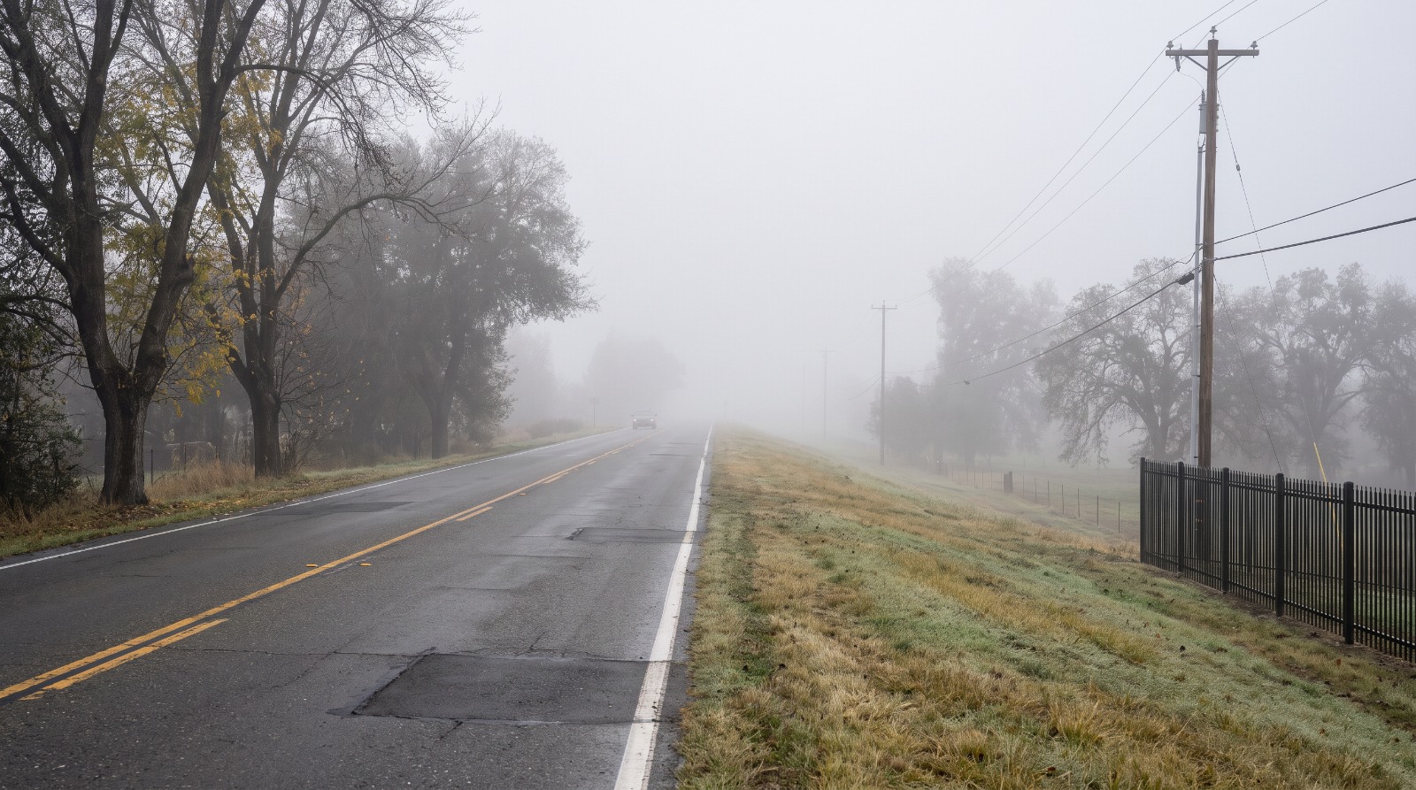
AI-rendered view of the Garden Highway on top of the Sacramento River levee at the edge of Natomas on a foggy winter morning Photo: Houseberry
We laid FEMA's flood map over all 167 mapped Houseberry neighborhoods in Sacramento. Only two have most of their land in the ordinary high-risk zones, and both are open ground: Cal Expo and the American River Parkway. The number that matters more is 26. That is how many neighborhoods, every one of them in Natomas, sit mostly inside a special high-risk zone called A99, where a federally backed mortgage still means mandatory flood insurance.
Almost everyone else lives in some version of Zone X. For 75 neighborhoods, from the Pocket to Land Park to East Sacramento, that X exists because a levee is holding back a river.
This is a good week to know which one you live in. NOAA's Climate Prediction Center said on October 8 that El Niño is still strengthening, with a greater than 83 percent chance it stays strong to very strong through March, according to its latest ENSO discussion. Its October 15 seasonal outlook gives much of California elevated odds of above-normal precipitation. The state has 4.4 million sandbags staged at 68 sites, the governor's office said on October 9.
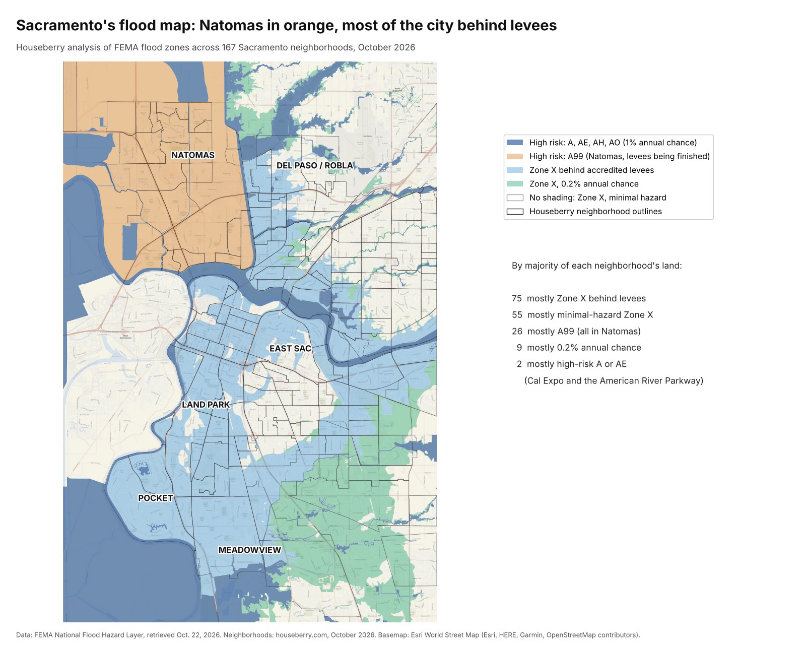
What the letters on your flood map mean
FEMA's zones read like a code. Here is the short translation, with what each one means for a buyer using a federally backed loan.
| Zone | What it means | Flood insurance required? |
|---|---|---|
| A, AE, AH, AO | A 1 percent chance of flooding in any year, the classic 100-year floodplain | Yes |
| AR | A temporary zone where a levee lost its certification and is being rebuilt | Yes |
| A99 | The step after AR, once FEMA agrees the rebuild is making real progress | Yes |
| X, shaded, behind a levee | Would be high risk without an accredited levee | No, but recommended |
| X, shaded, 0.2 percent | The 500-year area | No |
| X, unshaded | Minimal mapped hazard | No |
FEMA describes AR and A99 as temporary designations for levees under restoration. No part of the city carries an AR label on today's map. Natomas skipped straight to A99.
We built the map from FEMA's National Flood Hazard Layer, pulled October 22, 2026, and measured what share of each Houseberry neighborhood falls in each zone. Two cautions. River channels and lakes count as land in this math, so a neighborhood wrapped around water shows a high-risk share even if few homes are in it. And FEMA's map is a regulatory document. It tells you where insurance is required, not everywhere water can go.
Natomas stays A99 until the levee work is done
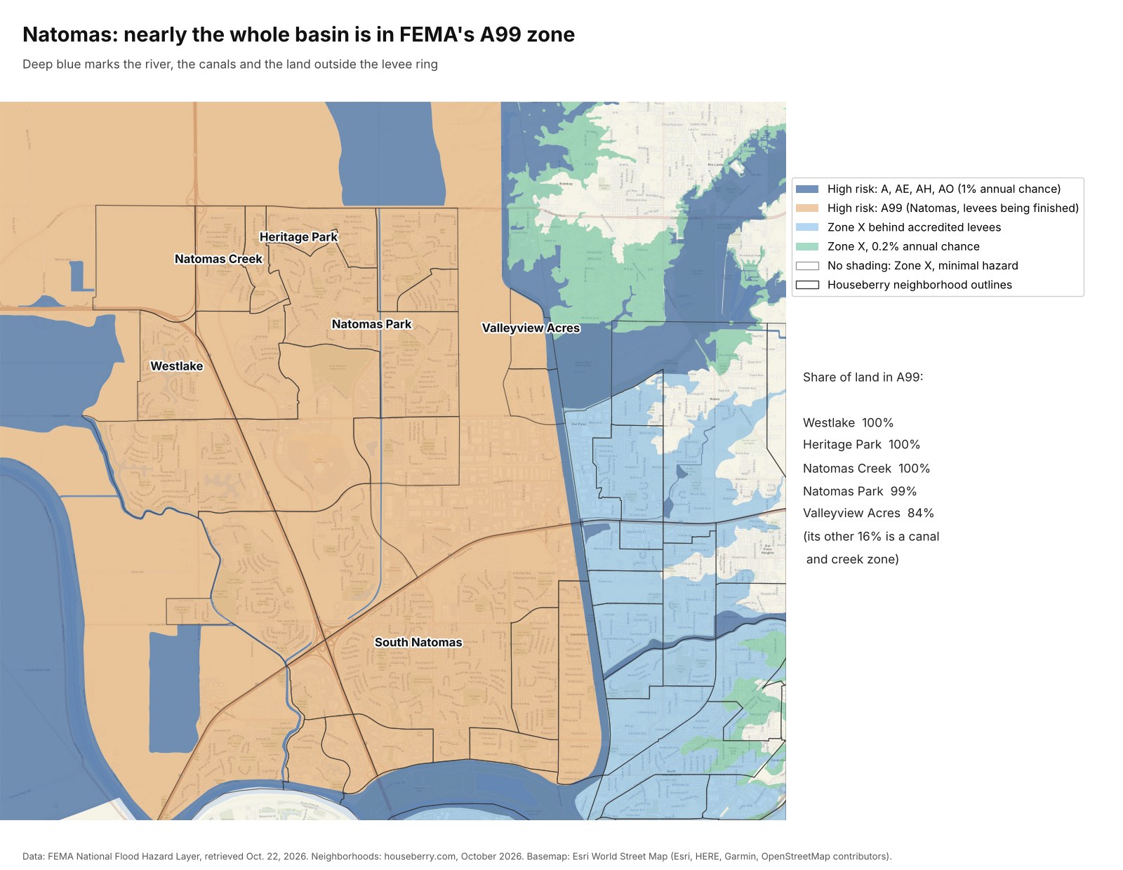
In December 2008, FEMA remapped the whole Natomas Basin into a high-risk AE zone, which required new homes to be raised as much as 20 feet in places. Building stopped. On June 16, 2015, the basin moved to A99, which let construction resume while the levees were rebuilt. A99 is "still considered a high risk flood zone," the city says, and owners with federally backed mortgages still need flood insurance.
Our numbers show how complete that is. Westlake, Heritage Park and Natomas Creek are 100 percent A99. Natomas Park is 99 percent. Valleyview Acres is 84 percent, and nearly all the rest is the high-risk strip along the canal on its east edge.
Here is the part the flood zone hides. Heritage Park scores 3.6 out of 5 and ranks 4th of 185 in Houseberry's Sacramento rankings, with a 4.5 safety score. Natomas Park is right behind it at 3.6 and 5th. Across all 26 neighborhoods that are mostly A99, the median Houseberry overall score is 2.9. The median for the 72 ranked levee-protected neighborhoods is 2.6. In Sacramento, the high-risk letter and the strong neighborhood score often sit on the same street.
The cost has also moved in Natomas' favor. When FEMA switched to its Risk Rating 2.0 pricing in 2021, a UC Davis analysis expected modest premium declines in the three Natomas ZIP codes, 95833, 95834 and 95835. The requirement goes away only when the levee work is finished and FEMA remaps the basin. CBS Sacramento reported in 2023 that dropping it could save some owners more than $1,400 a year. The Corps' remaining construction is covered in our look at the state levee audit.
The Pocket and Land Park are X because of the levee
South of downtown, the map is light blue. FEMA's label for it is "area with reduced flood risk due to levee," and it covers 94 percent of Land Park, 89 percent of the Pocket, 89 percent of Greenhaven and 76 percent of South Land Park. No lender will make you buy flood insurance there.
The Pocket also shows about 10 percent of its land in high-risk zones. Look at the close-up. That is the river side of the Sacramento River levee and the neighborhood's small lakes, not the cul-de-sacs.
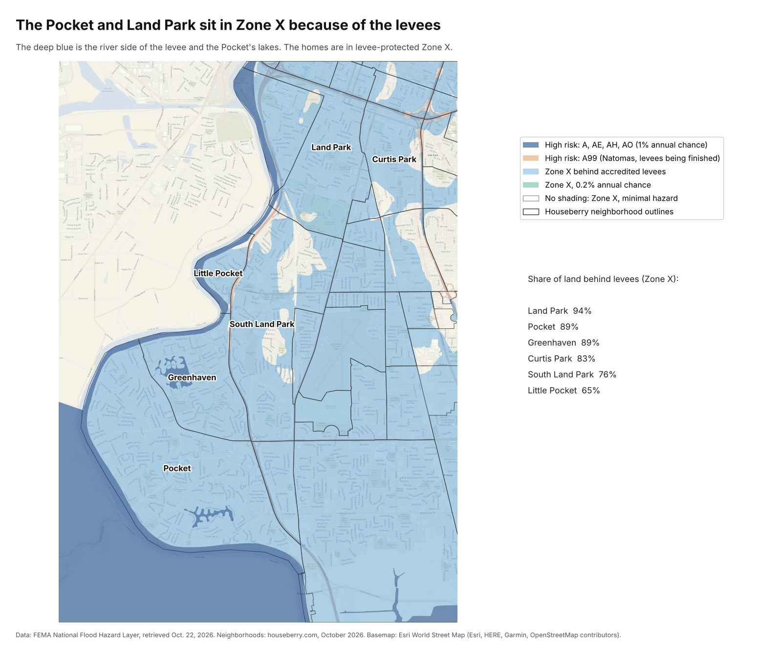
We think levee-protected X is the most misread zone in Sacramento. It is optional, and plenty of owners stop reading at that word. But the shading exists only because a levee is there. Sacramento County's own flood guidance recommends flood insurance whether or not a home is in a high-risk zone, and notes that homes outside one may qualify for a lower-cost preferred-risk policy. The UC Davis team expected the Pocket's ZIP code, 95831, to see premium increases under Risk Rating 2.0, because the new pricing looks at each home's elevation and distance to water.
These are not weak neighborhoods either. The Pocket scores 3.3 and ranks 16th, Greenhaven 3.2, and Land Park 3.1 with a 4.5 amenities score, among the highest in the city, according to Houseberry data.
Where the creeks cut through town
Outside Natomas, the ordinary high-risk zones mostly follow water you can name. These are the ranked Sacramento neighborhoods with the largest share of land in A or AE zones, leaving out Cal Expo and the Parkway itself.
| Neighborhood | Share in A or AE | Share behind levees (X) | Houseberry score |
|---|---|---|---|
| Old Sacramento | 30% | 29% | 2.4 |
| Del Paso Park | 30% | 0% | 2.2 |
| College Town | 29% | 71% | 2.1 |
| Little Pocket | 28% | 65% | 3.2 |
| River Park | 27% | 73% | 3.6 |
| Robla | 24% | 34% | 2.6 |
| Sierra Oaks | 23% | 63% | 3.1 |
| Campus Commons | 21% | 79% | 2.8 |
| Upper Land Park | 21% | 74% | 2.5 |
Shares are Houseberry analysis of FEMA's National Flood Hazard Layer, October 2026. The full list of 167 is in our working file.
Most of these are river-edge neighborhoods where the polygon runs past the levee. River Park, on a bend of the American River, is the clearest case: 27 percent in AE, nearly all of it the water side, and a 3.6 overall score that ranks 7th. Del Paso Park and Robla are different. Their high-risk land follows creeks through the neighborhood, and no levee shading backs it up. The county lists Arcade, Elder, Laguna and Hagginwood creeks among the streams that can overflow after heavy valley rain.
The neighborhoods on the highest ground
Fifty-five neighborhoods are mostly minimal-hazard Zone X. Fifteen ranked ones are essentially 100 percent, including Tahoe Park, Tahoe Park South, Elmhurst, Colonial Heights and Lincoln Village. Tahoe Park South ranks 10th overall. East Sacramento is split, 60 percent levee-protected and 40 percent minimal.
Minimal does not mean dry.
Street flooding from clogged storm drains does not show up on FEMA's map at all.
What El Niño does and does not promise
A strong El Niño raises the odds of a wet winter. It does not set the total. In the three very strong events on record, the Sacramento region got 163 percent of normal precipitation in 1982-83, 158 percent in 1997-98 and 104 percent in 2015-16, according to Golden Gate Weather Services. Strong events have ranged from 71 percent to 140. The governor's office put it plainly: El Niño "does not guarantee a wet winter or any particular storm." This one is unusual, though. The CPC put an 83 percent chance on a historic-strength reading for October through December.
How to check your own address
- Look up the parcel on FEMA's Map Service Center. The zone letter is the first thing to read.
- Check the state's MyHazards tool, which also shows what happens if a levee fails.
- The city's flood maps page has evacuation maps based on hypothetical 200-year levee breaks, and a map of flood depths with no levees at all. The city floodplain line is 916-808-5061. In unincorporated Sacramento County, call 916-874-7517.
- Ask an agent for a quote even in Zone X. The city earned FEMA's Class 2 community rating in 2018, worth up to 40 percent off premiums in its high-risk areas. The county kept its Class 2 rating last December, and its 40 percent discount applies to most policies issued or renewed after October 1, 2026.
Natomas owners already know their letter, because the lender told them at closing. Everyone in the Pocket, Land Park and the rest of the light blue should look theirs up before the first big December storm, then compare how the neighborhood scores on Houseberry's Sacramento rankings and the map. Our Bay Area flood zones map does the same for 1,213 neighborhoods from Marin to San Jose.
Sources
- FEMA National Flood Hazard Layer, flood hazard zones layer, retrieved October 22, 2026
- NOAA Climate Prediction Center, ENSO diagnostic discussion, October 8, 2026
- NOAA Climate Prediction Center, 90-day outlook discussion, October 15, 2026
- Office of the Governor, El Niño preparations, October 9, 2026
- City of Sacramento, Natomas floodplain
- FEMA, Zone AR and Zone A99
- UC Davis, What FEMA's new flood risk rating means for Californians
- CBS Sacramento, levee improvements and Natomas flood insurance, February 2023
- Sacramento County, Class 2 FEMA rating, December 2025
- Sacramento City Express, city earns Class 2 rating, October 2018
- Golden Gate Weather Services, El Niño and California precipitation
- Houseberry neighborhood scores and outlines, October 2026
The Houseberry Research Team is Houseberry's reporting team: Bay Area real estate analysts, data specialists and longtime local market watchers. Every day we check the public record: building permits, city council and planning agendas, county recorder filings, state housing bills, police incident data and school results. Then we tie each story to what it means for specific neighborhoods, using Houseberry's own neighborhood data on prices, appreciation, safety, schools and amenities. Questions or corrections: Contact us.
Map of Sacramento Neighborhoods
Loading map...
View Full Map
Top Neighborhoods in Sacramento, CA





All information provided on this website including but not limited to - school ratings, safety, amenities, user opinions, and property data - is for general informational purposes only. We do not guarantee its reliability, accuracy, or completeness. Users should independently verify information and consult appropriate professionals as needed. By using this website, you agree Houseberry is not responsible for actions, decisions, or consequences arising from reliance on the information provided
houseberry.com - CA DRE# 01847391
 Bay East ©2025. CCAR ©2025. bridgeMLS ©2025. Information Deemed Reliable But Not Guaranteed. This information is being provided by the Bay East MLS, or CCAR MLS, or bridgeMLS. The listings presented here may or may not be listed by the Broker/Agent operating this website. This information is intended for the personal use of consumers and may not be used for any purpose other than to identify prospective properties consumers may be interested in purchasing. Data last updated at October 22, 2026 12:00 AM